The average annual salinity of the waters of the World Ocean (in ppm). Data from the World Ocean Atlas, 2001
Sea water is a solution containing more than 40 chemical elements. The sources of salts are river runoff and salts supplied during volcanism and hydrothermal activity, as well as during underwater weathering of rocks - halmyrolysis. The total mass of salts is about 49.2 * 10 15 tons, this mass is enough for the evaporation of all ocean waters to cover the surface of the planet with a layer of layers 150 m thick. The most common anions and cations in waters are the following (in descending order): among the anions Cl -, SO 4 2-, HCO 3 -, among the anions Na +, Mg 2+, Ca 2+. Accordingly, in terms of layers, the largest amount falls on NaCl (about 78%), MgCl 2 , MgSO 4 , CaSO 4 . The salt composition of sea water is dominated by chlorides (while there are more carbonates in river water). It is noteworthy that the chemical composition of sea water is very similar to the salt composition of human blood. The salty taste of water depends on the content of sodium chloride in it, the bitter taste is determined by magnesium chloride, sodium and magnesium sulfates. The slightly alkaline reaction of sea water (pH 8.38-8.40) is determined by the predominant role of alkaline and alkaline earth elements - sodium, calcium, magnesium, potassium.
A significant amount of gases is also dissolved in the waters of the seas and oceans. Mostly it is nitrogen, oxygen and CO 2 . At the same time, the gas composition of sea waters is somewhat different from the atmospheric one - sea water, for example, contains hydrogen sulfide and methane.
Most of all, nitrogen is dissolved in sea water (10-15 ml / l), which, due to its chemical inertness, does not participate and does not significantly affect sedimentation and biological processes. It is assimilated only by nitrogen-fixing bacteria capable of converting free nitrogen into its compounds. Therefore, compared with other gases, the content of dissolved nitrogen (as well as argon, neon and helium) changes little with depth and is always close to saturation.
Oxygen entering the water in the process of gas exchange with the atmosphere and during photosynthesis. It is a very mobile and chemically active component of sea waters, therefore its content is very different - from significant to negligible; in the surface layers of the ocean, its concentration usually ranges from 5 to 9 ml/l. The supply of oxygen to the deep oceanic layers depends on the rate of its consumption (oxidation of organic components, respiration, etc.), on the mixing of waters and their transfer by currents. The solubility of oxygen in water depends on temperature and salinity; in general, it decreases with increasing temperature, which explains its low content in the equatorial zone and higher in cold waters of high latitudes. With increasing depth, the oxygen content decreases, reaching values of 3.0-0.5 ml/l in the oxygen minimum layer.
Carbon dioxide is contained in sea water in insignificant concentrations (no more than 0.5 ml/l), but the total content of carbon dioxide is approximately 60 times greater than its amount in the atmosphere. At the same time, it plays an important role in biological processes (being a source of carbon in the construction of a living cell), affects global climatic processes (participating in gas exchange with the atmosphere), and determines the features of carbonate sedimentation. In sea water, carbon oxides are distributed in free form (CO 2), in the form of carbonic acid and in the form of the HCO 3– anion. In general, the content of CO 2 , as well as oxygen, decreases with increasing temperature; therefore, its maximum content is observed in cold waters of high latitudes and in deep zones of the water column. With depth, the concentration of CO 2 increases, since its consumption decreases in the absence of photosynthesis and the supply of carbon monoxide increases during the decomposition of organic residues, especially in the layer of the oxygen minimum.
Hydrogen sulfide in sea water is found in significant quantities in water bodies with difficult water exchange (the Black Sea is a well-known example of "hydrogen sulfide contamination"). The sources of hydrogen sulfide can be hydrothermal waters coming from the depths to the ocean floor, reduction of sulfates by sulfate-reducing bacteria during the decomposition of dead organic matter, and the release of sulfur-containing organic residues during decay. Oxygen reacts rather quickly with hydrogen sulfide and sulfides, eventually oxidizing them to sulfates.
Important for the processes of oceanic sedimentation is the solubility of carbonates in sea water. Calcium in sea water contains an average of 400 mg / l, but a huge amount of it is bound in the skeletons of marine organisms, which dissolve when the latter die. Surface waters tend to be saturated with respect to calcium carbonate, so it does not dissolve in the upper water column immediately after the organisms die. With depth, the water becomes more and more undersaturated with calcium carbonate, and as a result, the rate at some depth of the dissolution rate of the carbonate substance is equal to the rate of its supply. This level is called depth of carbonate compensation. The depth of carbonate compensation varies depending on the chemical composition and temperature of sea water, averaging 4500 m. Below this level, carbonates cannot accumulate, which determines the replacement of essentially carbonate sediments by non-carbonate ones. The depth where the concentration of carbonates is equal to 10% of the dry matter of the sediment is called the critical depth of carbonate accumulation ( carbonate compensation depth).
Features of the relief of the ocean floor
Shelf(or continental shelf) - a slightly inclined, leveled part of the underwater margin of the continents, adjacent to the coast of the land and characterized by a common geological structure with it. Shelf depth is usually up to 100-200 m; shelf width ranges from 1-3 km to 1500 km (Barents Sea shelf). The outer boundary of the shelf is delineated by an inflection of the bottom topography - the edge of the shelf.
Modern shelves are mainly formed as a result of the flooding of the margins of the continents during the rise in the level of the World Ocean due to the melting of glaciers, as well as due to the subsidence of parts of the earth's surface associated with the latest tectonic movements. The shelf existed in all geological periods, in some of them growing sharply in size (for example, in the Jurassic and Cretaceous), in others, occupying small areas (Permian). The modern geological epoch is characterized by moderate development of shelf seas.
continental slope is the next of the main elements of the underwater margin of the continents; it is located between the shelf and the continental foot. It is characterized by steeper slopes of the surface compared to the shelf and ocean floor (on average 3-5 0, sometimes up to 40 0) and a significant dissection of the relief. Typical landforms are steps parallel to the crest and base of the slope, as well as submarine canyons, usually originating on the shelf and stretching to the continental foot. Seismic studies, dredging and deep-water drilling have established that, in terms of geological structure, the continental slope, like the shelf, is a direct continuation of the structures developed in the adjacent areas of the continents.
mainland foot is a plume of accumulative deposits that arose at the foot of the continental slope due to the movement of material down the slope (through turbidity flows, underwater landslides and landslides) and sedimentation of suspension. The depth of the continental foot reaches 3.5 km or more. Geomorphologically, it is a sloping hilly plain. Accumulative deposits that form the continental foot are usually superimposed on the ocean floor, represented by oceanic-type crust, or are located partly on the continental, partly on the oceanic crust.
Next are the structures formed on the crust of the oceanic type. The largest elements of the relief of the oceans (and the Earth as a whole) are the ocean floor and mid-ocean ridges. The bed of the ocean is divided by ridges, ramparts and hills into basins, the bottom of which is occupied by abyssal plains. These areas are characterized by a stable tectonic regime, low seismic activity and flat terrain, which allows them to be considered as oceanic plates - thalassocratons. Geomorphologically, these areas are represented by abyssal (deep water) accumulative and hilly plains. Accumulative plains have a leveled surface, a slightly inclined surface and are developed mainly along the periphery of the oceans in areas of significant inflow of sedimentary material from the continents. Their formation is associated with the supply and accumulation of material by suspension flows, which determines their inherent features: surface depression from the continental foot towards the ocean, the presence of submarine valleys, gradation layering of sediments, and leveled relief. The latter feature is determined by the fact that, moving deep into the ocean basins, sediments bury the primary dissected tectonic and volcanic relief. The hilly abyssal plains are characterized by a dissected relief and a small thickness of sediments. These plains are typical of the inner parts of the basins, remote from the coast. An important element of the relief of these plains are volcanic uplifts and individual volcanic structures.
Another element of the mega-relief is mid-ocean ridges, which are a powerful mountain system stretching across all the oceans. The total length of the mid-ocean ridges (MOR) is more than 60,000 km, the width is 200-1200 km, and the height is 1-3 km. In some areas, the peaks of the MOR form volcanic islands (Iceland). The relief is dissected, the relief forms are oriented mainly parallel to the length of the ridge. The sedimentary cover is thin, represented by carbonate biogenic silts and volcanogenic formations. The age of sedimentary strata becomes older with distance from the axial parts of the ridge; in the axial zones, the sedimentary cover is absent or is represented by modern deposits. MOR regions are characterized by intense manifestation of endogenous activity: seismicity, volcanism, high heat flux.
MOR zones are confined to the boundaries of the lithospheric plates moving apart, here the process of formation of a new oceanic crust takes place due to incoming mantle melts.
Particularly noteworthy are the transition zones from continental to oceanic crust - the margins of the continents. There are two types of continental margins: tectonically active and tectonically passive.
Passive Outskirts represent a direct continuation of the continental blocks, flooded by the waters of the seas and oceans. They include the shelf, the continental slope and the continental foot and are characterized by the absence of manifestations of endogenous activity. active ocarinas are confined to the boundaries of lithospheric plates, along which the subduction of oceanic plates under the continental ones takes place. These ocarinas are characterized by active endogenous activity; areas of seismic activity and modern volcanism are confined to them. Among the active ocarinas, two main types are distinguished by structure: the western Pacific (island-arc) and the eastern Pacific (Andean). The main elements of the margins of the Western Pacific type are deep-water trenches, volcanic island arcs, and marginal (or interarc) marine basins. The area of the deep-water trench corresponds to the boundary where the plate with the oceanic-type crust is being subducted. The melting of a part of the subducting plate and the rocks of the lithosphere located above (associated with the influx of water in the subducting plate, which sharply lowers the melting temperature of the rocks) leads to the formation of magma chambers, from which melts enter the surface. Due to active volcanism, volcanic islands are formed, stretching parallel to the boundary of the subsidence of the plate. The margins of the East Pacific type are distinguished by the absence of volcanic arcs (volcanism is manifested directly on the margin of the land) and marginal basins. The deep-water trench is replaced by a steep continental slope and a narrow shelf.
Destructive and accumulative activity of the sea
Abrasion (from lat. "abrasion" - scraping, shaving) is the process of destruction of rocks by waves and currents. Abrasion occurs most intensively near the coast under the action of the surf.
The destruction of coastal rocks is composed of the following factors:
wave impact (the strength of which reaches 30-40 t / m 2 during storms);
· abrasive action of clastic material brought by the wave;
dissolution of rocks;
· compression of air in the pores and cavities of the rock during the impact of waves, which leads to cracking of rocks under the influence of high pressure;
· thermal abrasion, which manifests itself in the thawing of frozen rocks and ice shores, and other types of impact on the coast.
 The impact of the abrasion process is manifested to a depth of several tens of meters, and in the oceans up to 100 m or more.
The impact of abrasion on the coast leads to the formation of clastic deposits and certain landforms. The abrasion process proceeds as follows. Hitting the shore, the wave gradually develops a depression at its base - wave-cutting niche, over which hangs a cornice. As the wave-cut niche deepens, under the action of gravity, the cornice collapses, the fragments are at the foot of the coast and, under the influence of waves, turn into sand and pebbles.
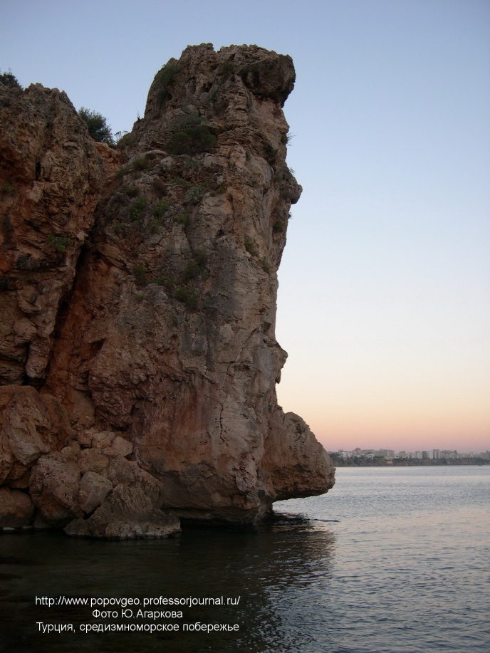
The cliff or steep ledge formed as a result of abrasion is called cliff. At the site of the retreating cliff, a abrasion terrace, or bench (English "bench"), which is composed of bedrock. The cliff may border directly on the bench or be separated from the latter by a beach. The transverse profile of the abrasion terrace has the form of a convex curve with small slopes near the shore and large slopes at the base of the terrace. The resulting clastic material is carried away from the shore, forming underwater accumulative terraces.
As the abrasion and accumulative terraces develop, the waves find themselves in shallow water, turn up and lose energy before reaching the root bank, because of this, the abrasion process stops.
Depending on the nature of the ongoing processes, the coast can be divided into abrasion and accumulative.
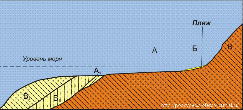
A, B, C - different stages of retreat of the coastal cliff, destroyed by abrasion; A 1 , B 2 , C 3 - different stages of development of the underwater accumulative terrace.
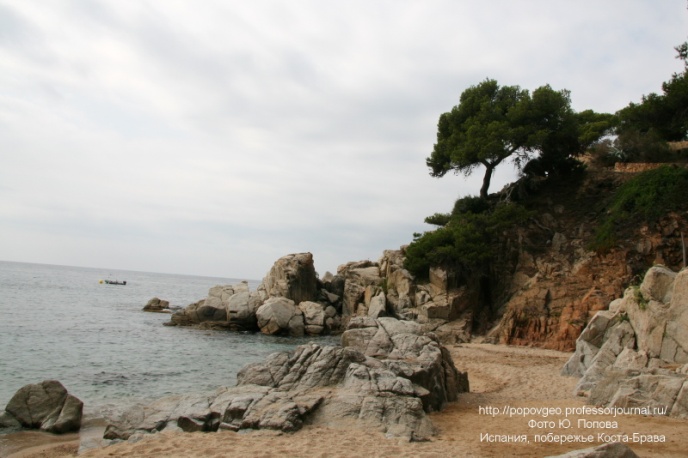 Waves carry out not only destructive work, but also the work of moving and accumulating detrital material. The oncoming wave carries pebbles and sand, which remain on the shore when the wave retreats, this is how beaches are formed. By the beach(from the French "plage" - sloping seashore) is called a strip of sediment on the sea coast in the zone of action of a surf stream. Morphologically, beaches of a full profile are distinguished, having the form of a gentle swell, and beaches of an incomplete profile, which are an accumulation of sediment inclined towards the sea, adjoining the foot of the coastal cliff with its back side. Beaches of a full profile are typical for accumulative shores, incomplete - mainly for abrasion shores.
When waves are burrowing at depths of a few meters, the material deposited under water (sand, gravel or shell) forms an underwater sand bank. Sometimes the underwater accumulative shaft, growing, protrudes above the surface of the water, stretching parallel to the shore. Such shafts are called bars(from the French "barre" - barrier, shoal).
The formation of a bar can lead to the separation of the coastal part of the sea basin from the main water area - lagoons are formed. Lagoon (from lat. lacus - lake) is a shallow natural water basin, separated from the sea by a bar or connected to the sea by a narrow strait (or straits). The main feature of the lagoons is the difference between the salinity of the waters and biological communities.
Sedimentation in the seas and oceans
Various precipitation accumulates in the seas and oceans, which can be divided into the following groups by origin:
· terrigenous, formed due to the accumulation of products of mechanical destruction of rocks;
biogenic, formed due to the vital activity and death of organisms;
chemogenic, associated with precipitation from sea water;
· volcanic, accumulating as a result of underwater eruptions and due to products of eruption brought from land;
polygenic, i.e. mixed sediments formed due to material of different origin.
In general, the material composition of bottom sediments is determined by the following factors:
· depth of sedimentation area and bottom topography;
hydrodynamic conditions (the presence of currents, the influence of wave activity);
· the nature of the supplied sedimentary material (determined by climatic zonality and distance from the continents);
biological productivity (marine organisms extract minerals from the water and deliver them to the bottom after dying (in the form of shells, coral structures, etc.));
volcanism and hydrothermal activity.
One of the determining factors is the depth, which makes it possible to distinguish several zones that differ in the features of sedimentation. Littoral(from lat. "littoralis"- coastal) - the border strip between land and sea, regularly flooded at high tide and drained at low tide. The littoral is the zone of the seabed located between the levels of the highest tide and the lowest tide. nerite zone corresponds to the depths of the shelf (from the Greek. "erites"- sea mollusk). Bathyal zone(from the Greek "deep") roughly corresponds to the area of the continental slope and foot and depths of 200 - 2500 m. This zone is characterized by the following environmental conditions: significant pressure, almost complete absence of light, slight seasonal fluctuations in temperature and water density; representatives of zoobenthos and fish predominate in the organic world, the plant world is very poor due to the lack of light. abyssal zone(from the Greek "bottomless") corresponds to sea depths of more than 2500 m, which corresponds to deep-water basins. The waters of this zone are characterized by relatively low mobility, constantly low temperature (1-2 0 C, in the polar regions below 0 0 C), constant salinity; there is no sunlight at all and enormous pressures are achieved, which determine the originality and poverty of the organic world. Areas deeper than 6000 m are usually distinguished as ultra-abyssal zones corresponding to the deepest parts of the basins and deep-water trenches.