The Paleogene period of the geological history of the Earth, which began 67 million years ago, lasted 41 million years. The next, Neogene, is 25 million years old. The last, the shortest, is about 1 million years old. They call it glacial.
The idea was established that the surface of land and sea, even the bowels of the planet, were influenced by powerful glaciations. Data have been obtained that testify to the gradual cooling of the Earth's climate from the time of the Paleogene (60-65 million years ago) to the present day. The average annual air temperature in temperate latitudes has decreased from 20 ° C, characteristic of the tropical zone, to 10 ° C. Under current climatic conditions, glaciation processes form and develop over an area of 52 million square kilometers. They cover a tenth of the planet's surface.
Over the past 700 thousand years, scientists believe, in the north of Eurasia and North America there were huge ice sheets in length - much more extensive than modern Greenland and even Antarctic. The dimensions of this paleoglaciation are estimated by a prominent specialist in this field - an American scientist of the Russian Federation. Flint - 45.2 million square kilometers. North America accounted for 18, Greenland - 2, Eurasia - 10 million square kilometers of ice. In other words, the estimated area of glaciation in the Northern Hemisphere was more than twice as large as in today's Antarctica (14 million square kilometers). In the works of glaciologists, ice sheets are reconstructed in Scandinavia, the North Sea, a large part of England, the plains of Northern Europe, the lowlands and mountainous regions of northern Asia, and almost throughout Canada, Alaska, and the northern United States. The thickness of these shields is determined at 3-4 kilometers. Grandiose (up to global) changes in the natural situation on Earth are associated with them.
Experts paint very impressive pictures of the past. They believe that under the onslaught of ice coming from the North, ancient people and animals left their habitats and sought refuge in the southern regions, where the climate was then much colder than now.
It is believed that the level of the World Ocean at that time dropped by 100-125 meters, since the ice sheets "fettered" a huge amount of its waters. When the glaciers began to melt, the sea flooded the vast low-lying expanses of land. (The legend of the Flood is sometimes associated with the alleged advance of the sea on the continents.)
How true are the ideas that science has about the last ice age? - the question is relevant. Knowledge of the nature, size of ancient glaciers, the scale of their geological activity is necessary to explain many aspects of the development of nature and ancient man. The latter is especially important. We live in the Quaternary period, which is called anthropogenic.
Knowing the past, you can predict the future. Therefore, scientists are thinking about whether a new “great glaciation” threatens humanity in the near or distant future.
So, what can humanity expect if the climate on Earth again becomes much colder than the current one?
WE GET TOGETHER WITH IDEAS AS WITH PEOPLE
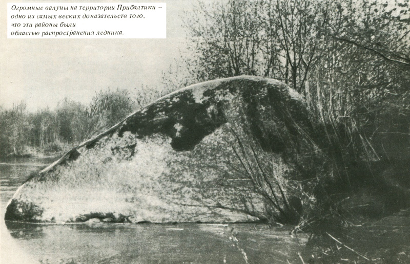
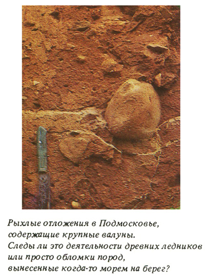
The book "Studies on the Ice Age", written by a prisoner of the Peter and Paul Fortress - the famous scientist and revolutionary P.A. Kropotkin, - was published in 1876. His work fully and clearly outlined the ideas about the "great glaciation", which originated in the mountains of Scandinavia, filled the basin of the Baltic Sea and went out to the Russian Plain and the Baltic lowlands. This concept of ancient glaciation has been widely recognized in Russia. One of its main reasons is the fact of the distribution of peculiar deposits on the plains of Northern Europe: unsorted clays and loams containing stone fragments in the form of pebbles and boulders, the dimensions of which reached 3-4 meters in diameter.
Previously, scientists, following the great naturalists of the 19th century C. Lyell and C. Darwin, believed that loams and clays were deposited at the bottom of cold seas - the modern plains of Northern Europe, and boulders were carried by floating ice.
"Drift (from the word "drift") theory", quickly losing supporters, retreated under the onslaught of the ideas of P.A. Kropotkin. They bribed the opportunity to explain many mysterious facts. Where, for example, did deposits containing large boulders come from on the plains of Europe? The glaciers, advancing on a wide front, later melted, and these boulders appeared on the surface of the earth. It sounded quite convincing.
Thirty-three years later, German researchers A. Penk and E. Brückner, who studied the territory of Bavaria and expressed the idea of a fourfold ancient glaciation of the Alps, decided to clearly link each of its stages with the river terraces of the upper Danube basin.
The glaciations have been given names mainly by tributaries of the Danube. The oldest is “gunz”, the younger one is “mindel”, then followed by “riss” and “wurm”. Traces of them subsequently began to be sought and found on the plains of Northern Europe, in Asia, North and South America, and even in New Zealand. Researchers persistently linked the geological history of this or that region with the "reference" Central Europe. No one thought about whether it is legitimate to single out ancient glaciations in North or South America, East Asia, or the islands of the Southern Hemisphere by analogy with the Alps. Soon, glaciations corresponding to the Alpine ones appeared on the paleogeographic maps of North America. They received the names of the states, which, scientists believe, reached by descending to the south. The most ancient - Nebrassian - corresponds to Alpine gyunts, Kansas - to almond, Illinois - to rice, Wisconsin - to wurm.
The concept of four ice sheets in the recent geological past was also adopted for the territory of the Russian Plain. They were named (in descending order of age) Oka, Dnieper, Moscow, Valdai and correlated with Mindel, Ris, Wurm. But what about the oldest alpine glaciation - gunz? Sometimes, under different names, a fifth glaciation corresponding to it is distinguished on the Russian Plain.
The attempts made in recent years to “improve” the Alpine model led to the identification of two more pre-Gyuntsev (earliest) “great glaciations” - the Danube and the Biber. And due to the fact that two or three are compared with some of the alleged Alpine glaciations (on the plains of Europe and Asia), their total number in the Quaternary period reaches, according to some scientists, eleven or more.
They get used to ideas, become related, as with people. Parting with them is sometimes very difficult. The problem of the ancient "great glaciations" in this sense is no exception. The data accumulated by scientists on the structure, time of origin and history of the development of the current ice sheets of Antarctica and Greenland, on the regularities of the structure and formation of modern frozen rocks and the phenomena associated with them, cast doubt on many ideas common in science about the nature, extent of manifestation of ancient glaciers and their geological activity. However (traditions are strong, the energy of thinking is great), these data are either not noticed, or they are not given any importance. They are not comprehended in a new way and are not seriously analyzed. Let us consider in their light the problem of ancient glaciations and try to understand what actually happened to the nature of the Earth in the recent geological past.
FACTS VS THEORIES
A quarter of a century ago, almost all scientists agreed that the modern ice sheets of Antarctica and Greenland developed in sync with the supposed "great glaciers" in Europe, Asia, and North America. The glaciation of the Earth, they believed, began in Antarctica, Greenland, on the Arctic islands, then covered the continents of the Northern Hemisphere. During the interglacial epochs, the Antarctic and Greenland ice melted completely. The level of the World Ocean rose by 60-70 meters above the present. Significant areas of the coastal plains were flooded by the sea. No one doubted that the modern era is an unfinished ice age. Say, the ice sheets simply did not have time to melt. Moreover, during cooling epochs, not only huge glaciers appeared on the continents of the Northern Hemisphere, but the Greenland and Antarctic ice sheets grew significantly ... Years passed, and the results of studies of hard-to-reach polar regions completely refuted these ideas.
It turned out that glaciers in Antarctica appeared long before the "ice age" - 38-40 million years ago, when subtropical forests stretched across the north of Eurasia and North America, and palm trees swayed on the shores of modern Arctic seas. About any glaciation on the continents of the Northern Hemisphere then, of course, there can be no question. The Greenland ice sheet also originated at least 10-11 million years ago. At that time, mixed forests grew on the coasts of the Arctic seas in northern Siberia, Alaska and Canada (among birch, alder, spruce, larch, there were broad-leaved oak, linden, elm), corresponding to a warm, humid climate.
Data on the antiquity of the ice sheets of Antarctica and Greenland sharply raised the question of the causes of the glaciation of the Earth. They are seen in global warmings and coolings of the climate. (Back in 1914, the Yugoslav scientist M.Milankovic drew graphs of fluctuations in the arrival of solar radiation on the earth's surface over the past 600 thousand years, identified with glaciations and interglacial periods.) But we now know that when the climate was warm in the north of Eurasia and North America , Antarctica and Greenland were covered by ice sheets, the size of which later never significantly decreased. This means that it is not a matter of fluctuations in the arrival of solar heat and general cooling and warming of the earth, but in a combination of certain factors leading to glaciation in these specific conditions.
The exceptional stability of the Greenland and Antarctic ice sheets does not support the concept of the repeated development and disappearance of the "great glaciations" on the continents of the Northern Hemisphere. It is not clear why the Greenland ice sheet has continuously existed for more than 10 million years, while next to it in less than 1 million years, due to some completely unclear reasons, the North American one has repeatedly appeared and disappeared.
Put two pieces of ice on the table - one 10 times larger than the other. Which one will melt faster? If the question seems rhetorical, ask yourself: which ice sheet was supposed to disappear first with the general warming of the climate in the Northern Hemisphere - Greenland with an area of \u200b\u200b1.8 million square kilometers or the proposed North American one next to it - 10 times larger? Obviously, the second one was more resistant (in time) to all external changes.
Relying on the now dominant theory, this paradox cannot be explained. According to it, a huge hypothetical North American ice sheet has arisen over the past 500-700 thousand years four or five or more times, that is, approximately every 100-150 thousand years, and the size of the adjacent (incomparably smaller) one has hardly changed. Incredible!
If the stability of the Antarctic ice cover for tens of millions of years (let us assume that the glaciers of the Northern Hemisphere arose and disappeared at that time) can be explained by the proximity of the mainland to the pole, then in relation to Greenland it should be remembered: its southern tip is located near 60 degrees north latitude - on one parallels with Oslo, Helsinki, Leningrad, Magadan. So could the alleged "great glaciations" come and go in the Northern Hemisphere as often as is commonly claimed? Unlikely. As for the criteria and methods for establishing their number, they are unreliable. Eloquent proof of this is the discrepancy in estimating the number of glaciations. How many of them were there: 1-4, 2-6, or 7-11? And which of them can be considered the maximum?
The terms "cooling" and "glaciation" are usually used as synonyms. It goes without saying, it seems, of course: the colder the climate of the Earth was, the wider the front that ancient glaciers advanced from the north. They say: "there were so many epochs of cooling", implying that there were the same number of epochs of glaciation. However, the latest research has raised many unexpected questions.
A. Penk and E. Brueckner considered the most ancient or one of the most ancient glaciations of the ice age to be the maximum. They were convinced that the sizes of the subsequent ones were consistently decreasing. In the future, the opinion became stronger and almost completely dominated: the largest was the glaciation that occurred in the middle of the ice age, and the most limited was the last. For the Russian Plain it was an axiom: the most extensive Dnieper glaciation, which had two large "tongues" along the valleys of the Dnieper and Don, descended along them south of the latitude of Kyiv. The borders of the next - Moscow were drawn much to the north (somewhat south of Moscow), even younger - Valdai was drawn north of Moscow (about halfway from it to Leningrad).
The limits of distribution of hypothetical ice covers on the plains are restored in two ways: according to the deposits of ancient glaciers (till - an unsorted mixture of clay, sand, large stone fragments), according to landforms and according to a number of other signs. And here's what is remarkable: within the limits of the distribution of the youngest (from the supposed) glaciation, deposits were found, which were then attributed to all or almost all of the previous ones (two, three, four, etc.). Near the southern borders of the Dnieper glaciation (in the valleys of the Dnieper and Don in their lower reaches), only one layer of till is found, as is the case near the southern limits of the supposedly maximum Illinois (in North America). And here and there to the north, more layers of sediments are established, which, for one reason or another, are classified as glacial.
In the north and especially the northwest, the relief of the Russian Plain has sharp ("fresh") outlines. The general character of the area suggests that until recently there was a glacier, which gave Leningraders and the inhabitants of the Baltic region their favorite places for recreation and tourism - picturesque combinations of ridges, hills and lakes lying in depressions between them. Lakes on the Valdai and Smolensk Uplands are often deep and are characterized by transparency and purity of water. And south of Moscow, the landscape is changing. There are almost no areas of hilly-lake relief. Ridges and gently sloping hills predominate, cut by river valleys, streams and ravines. Therefore, it is believed that the glacial relief that was once here has been reworked and changed almost beyond recognition. Finally, the southern limits of the supposed distribution of ice sheets in Ukraine and along the Don are characterized by dissected spaces cut by rivers, almost devoid of signs of glacial relief (if it was here), which gives, they say, reason to believe that the local glacier is one of the most ancient .. .
All these ideas, which seemed indisputable, have recently been shaken.
PARADOX OF NATURE
The results of studying ice from cores of deep wells in Antarctica, Greenland and bottom sediments of the oceans and seas turned out to be sensational.
From the ratio of heavy to light oxygen isotopes in ice and marine organisms, scientists can now determine ancient temperatures at which ice accumulated and sediment layers were deposited on the seafloor. It turned out that one of the strongest cold snaps occurred not at the beginning and middle of the "Ice Age", but almost at its very end - at a time interval that is 16-18 thousand years from our days. (Earlier it was assumed that the largest glaciation was 84-132 thousand years older.) Signs of a very sharp cooling of the climate at the end of the "Ice Age" were also found by other methods in different parts of the Earth. In particular, along the ice veins in the north of Yakutia. The conclusion that our planet has recently experienced one of the coldest or coldest epochs seems now very reliable.
But how to explain the phenomenal natural paradox, which consists in the fact that the time of a very severe climate corresponds to the minimum of the supposed ground ice sheets? Finding themselves in a "dead end" position, some scientists took the easiest path - they abandoned all previous ideas and suggested that the last glaciation be one of the maximum, since the climate at that time was one of the coldest. Thus, the whole system of geological proofs of the sequence of natural events in the ice age is denied, the whole building of the “classical” glacial concept collapses.
MYTHICAL PROPERTIES OF GLACIERS
It is impossible to understand the complex issues of the history of the "Ice Age" without first studying the problems of the geological activity of ancient glaciers. The traces left by them are the only evidence of their spread.
Glaciers are of two main types: large shields or domes, merging into huge sheets, and mountain glaciers (glaciers). The geological role of the former is most fully covered in the works of the American scientist R.F. Flint, who summarized the ideas of many scientists (including Soviet ones), according to which glaciers perform a huge destructive and creative work - they plow out large ruts, depressions and accumulate powerful strata of sediments. It is assumed, for example, that they, like a bulldozer, are capable of scraping out hollows several hundred meters deep, and in some cases (Sogne Fjord in Norway) - up to 1.5-2.5 thousand meters (the depth of this fiord is 1200 m plus the same height slopes). Not bad at all, if we keep in mind that the glacier was supposed to “dig” hard rocks here. True, most often the formation of basins with a depth of "only" 200-300 meters is associated with glacial ploughing. But now it is established with a sufficient degree of accuracy that the ice moves in two ways. Either its blocks slide along the cracks, or the laws of viscoplastic flow operate. Under prolonged and ever-increasing stresses, solid ice becomes plastic and begins to flow, albeit very slowly.
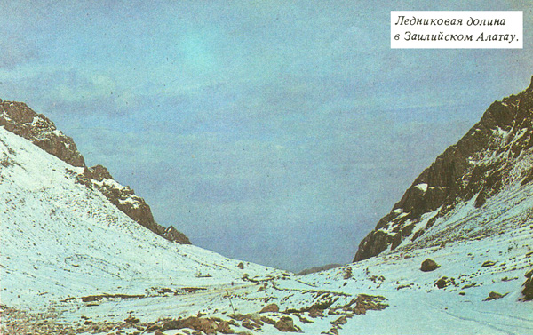
In the central parts of the Antarctic cover, the speed of ice movement is 10-130 meters per year. It slightly increases only in the original "ice rivers" flowing in the icy shores (outflow glaciers). The movement of the bottom part of the glaciers is so slow and smooth that they are physically unable to perform the grandiose work that is attributed to them. And does the glacier touch the surface of its bed everywhere? Snow and ice are good heat insulators (the Eskimos have long built their dwellings from compressed snow and ice), and small amounts of intraterrestrial heat are constantly supplied from the bowels of the earth to its surface. In covers of great thickness, the ice melts from below, rivers and lakes appear under it. In Antarctica, near the Soviet station "Vostok" under the four-kilometer thickness of the glacier, there is a reservoir with an area of 8 thousand square kilometers! This means that the ice not only does not tear off the underlying rocks here, but, as it were, “floats” above them or, if the water layer is small, slides over their wetted surface. Mountain glaciers in the Alps, the Caucasus, Altai and other regions are advancing at an average speed of 100-150 meters per year. Here, too, their bottom layers mainly behave as a viscous-plastic substance and flow in accordance with the law of laminar flow, adapting to the unevenness of the bed. Therefore, they cannot plow trough-shaped trough-shaped valleys several kilometers wide and 200-2500 meters deep. This is supported by interesting observations.
In the Middle Ages, the area of glaciers in the Alps increased. They moved down the river valleys and buried the buildings of the Roman era under them. And when the Alpine glaciers receded again, from under them appeared the perfectly preserved foundations of buildings destroyed by people and earthquakes, and paved Roman roads with wagon ruts knocked out on them. In the central part of the Alps, near Innsbruck in the valley of the Inn River, under the deposits of a retreating glacier, layered sediments of an ancient lake (with the remains of fish, leaves and tree branches) were found that existed here about 30 thousand years ago. This means that the glacier that has moved onto the lake has practically not damaged the layer of soft sediments - it has not even crushed them.
What is the reason for the large width and trough-shaped shape of the valleys of mountain glaciers? It seems that with the active collapse of the slopes of the valleys as a result of weathering. A huge amount of fragments of stone material turned out to be on the surface of the glaciers. The moving ice, like a conveyor belt, carried them down. The valleys were not cluttered. Their slopes, while remaining steep, quickly receded. They acquired a greater width and a transverse profile resembling a trough: a flat bottom and steep sides.
To recognize the ability of glacial flows to mechanically destroy rocks is to attribute mythical properties to them. Due to the fact that glaciers do not plow their bed, in many valleys, now free of ice, ancient river deposits and placers of gold and a number of other valuable minerals associated with them have been preserved. If the glaciers had produced the huge destructive work attributed to them, contrary to facts, logic and physical laws, there would have been no “gold rushes” of Klondike, Alaska in the history of mankind, and Jack London would not have written several wonderful novels and stories.
A variety of creative geological activities are also associated with glaciers. But often this is done without proper justification. In the mountains, indeed, strata are often found, consisting of a chaotic mixture of blocks, rubble and sand, sometimes blocking the valleys from one slope to another. They are sometimes composed of sections of valleys that are significant in length. On the plains, deposits of ancient ice sheets usually include unstratified and unsorted clays, loams, sandy loams containing stone inclusions - mainly pebbles and boulders. However, it is known that in cold-water lakes, boulders can be carried by floating ice. They are also carried by river ice. Therefore, many varieties of marine and river sediments contain stone inclusions. It is impossible to classify them as glacial deposits on this basis alone. Mudflows play an important role here, most intense in the mountains or foothills and in belts, which are characterized by alternation of rainy (wet) and dry periods.
One of the obvious evidence of the glacial origin of such deposits is considered to be "boulder blind areas" - accumulations of boulders, the upper surface of which is allegedly worn away by ice. We just proved that the glacier couldn't do that. Those who have been on the shores of polar rivers and seas know that boulder pavements are a common occurrence here. With sharp ice movements in the coastal zone, it does an impressive job: it cuts off the protruding convex edges of boulders, steel pipes and concrete piles like a razor. Boulder-bearing deposits of unsorted clays and loams contain remains of shells of marine organisms. Therefore, they accumulated in the sea. Sometimes there are boulders, to the smooth surface of which sea shells are attached. Such finds do not at all testify in favor of the glacial origin of these rounded boulders.
GEOLOGICAL ROLE OF UNDERGROUND GLACIATION
Under the influence of ideas about "great" terrestrial superglaciers, the role of underground glaciation in the history of the Earth was either not noticed, or its nature was interpreted erroneously. This phenomenon was sometimes spoken of as a phenomenon accompanying ancient glaciations.
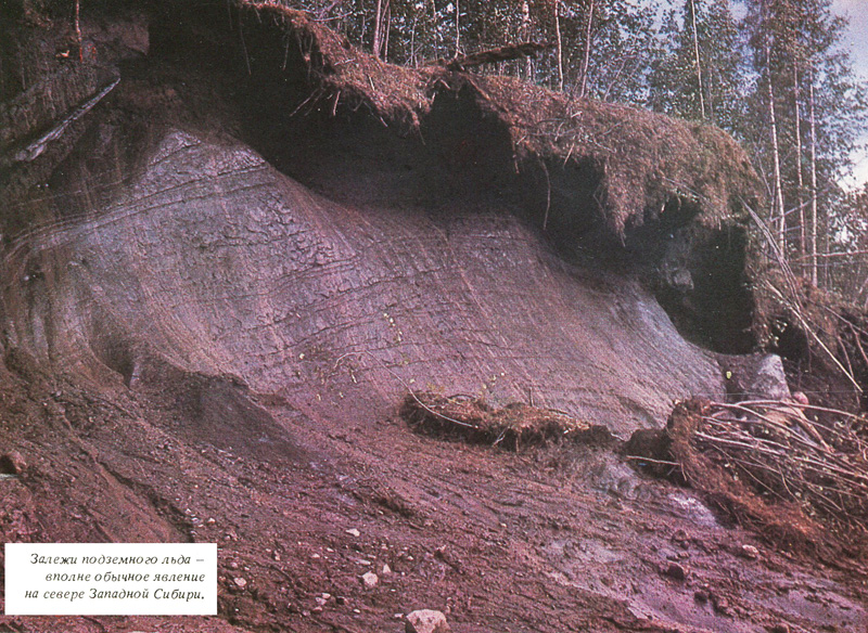
The distribution zone of frozen rocks on Earth is very large. It occupies about 13 percent of the land area (in the USSR - almost half of the territory), includes vast expanses of the Arctic and Subarctic, and in the eastern regions of the Asian continent it reaches middle latitudes.
Terrestrial and underground glaciation as a whole are characteristic of the cooling regions of the Earth, i.e., regions with negative average annual air temperatures experiencing a heat deficit. An additional condition for the formation of terrestrial glaciers is the predominance of solid atmospheric precipitation (snow) over their consumption, and underground glaciation is confined to areas where there is not enough precipitation. First of all - to the territory of the north of Yakutia, the Magadan region and Alaska. In Yakutia, where very little snow falls, there is a cold pole of the Northern Hemisphere. A record low temperature was recorded here - minus 68°C.
For the zone of distribution of frozen rocks, underground ice is most characteristic. Most often, these are interlayers and veinlets, more or less evenly distributed in the strata of sediments. Intersecting with each other, they often form an ice grid or lattice. There are also deposits of underground ice with a thickness of up to 10-15 meters or more. And its most impressive variety is vertical ice veins 40-50 meters high and over 10 meters wide in the upper (thickest) part.
In accordance with the concept of V.A. Obruchev, large ice veins, lenses and layers of underground ice were quite recently considered buried remains of former ice sheets and substantiated by this the theoretical reconstruction of a huge ice sheet almost throughout Siberia up to the Arctic seas and their islands.
Soviet (mainly) scientists have uncovered the mechanism of formation of ice veins. At low temperatures, the ground, covered with a thin layer of snow, cools intensively, shrinks and breaks into cracks. In winter they get snow, in summer water. It freezes as the lower ends of the cracks penetrate into the sphere of permanently frozen rocks with temperatures below 0°C. The periodic occurrence of new cracks in the old place and their filling with additional portions of snow and water lead first to the formation of wedge-shaped ice veins no more than 12-16 meters high. In the future, they grow in height and width, squeezing out part of the mineral matter containing them to the earth's surface. The latter is constantly rising due to this - the ice veins, as it were, are "buried" in the ground. With an increase in the depth of occurrence, conditions are created for their further upward growth. It stops when the total ice saturation of the deposits reaches a maximum value of 75-90 percent of the total volume of the entire ice-ground mass. The total increase in the surface can reach 25-30 meters. According to calculations, the formation of ice veins of large vertical extent requires 9-12 thousand years.
When the possibilities for the growth of an ice vein are exhausted, it opens up and begins to thaw. A thermokarst funnel arises, which, in the absence of runoff from it, turns into a lake, which often has a cruciform shape due to the fact that it is located at the mutual intersection of ice veins. There comes a stage of mass thawing of icy rocks.
Ice veins give rise to lakes, and lakes eliminate them, preparing the conditions for the reappearance and development of ice veins.
The question of the connection between the formation of large ice veins and frost cracking of soils and freezing of water in them has been resolved almost unambiguously, only the details of this process and its connection with certain landscapes in continental land conditions are discussed. The problem of the origin of large deposits of underground ice in the form of lenses and layers turned out to be more complex and is still the subject of heated discussion. Some scientists believe that these are the buried remains of ancient glaciers. Others argue that such deposits are formed in the process of soil freezing. Some researchers incorrectly attribute buried lenses and layers of ice that were once carried by the sea to land as glacial.
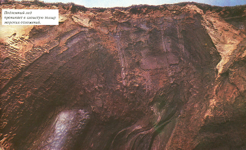
There are especially many lenses and layers of underground ice in the north of the West Siberian Lowland and the coastal plains of Chukotka. The results of the work of Soviet permafrost scientists there allow us to draw a quite definite conclusion: underground lenses and layers of ice in these areas were formed in the process of freezing of rocks and are a characteristic consequence of it. A number of details of their structure (first of all, the presence of large stone inclusions - pebbles and boulders in underground ice deposits) do not fit into the framework of standard ideas about underground ice formation. It is the boulders that are considered as the main and direct evidence that the ice containing them is the remnants of former ice sheets. However, the hit of boulders in massifs of “pure” underground ice is quite understandable. Rocks are broken by cracks. The water that penetrated into them, freezing, pushed the boulders up, where they were enveloped by “clean” ice.
Another specific feature of underground lenticular ice deposits is their sometimes inherent folding. As they grow towards the surface, the ice veins collapse into dome-shaped folds overlying their deposits. It is assumed that the deformations in the ice reflect the process of the former movement of the glacier, and the crushing of rocks is associated with its dynamic effect on its bed (“glaciodynamic dislocations”). We have already spoken about the unreality of such ideas. Deformed large accumulations of underground ice of a lenticular shape are the intrusions of water and soil in the process of freezing of sediments after their surface was above sea level. The validity of this point of view is unambiguously evidenced by the fact that in a number of cases, accumulations of deformed ice are overlain by marine layered sediments crumpled into gentle folds and containing the remains of marine organisms.
The theory of ancient glaciations is usually used to explain natural phenomena that baffle the researcher, who cannot give a plausible interpretation of the method of their formation. This is exactly the case with the problem of the origin of deposits of underground ice containing boulders. However, the absence of an explanation for a complex natural phenomenon is not evidence that it is necessarily due to the activity of an ancient glacier.
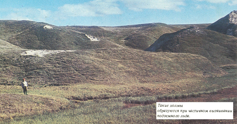
Finally, the study of the area of modern distribution of frozen rocks provides the key to deciphering the origin of the characteristic hilly-depression relief, which is commonly called "typically glacial." The fact is that underground ice in frozen rocks is distributed very unevenly. Its amount is often equivalent to raising the height of the earth's surface by 40-60 meters. Naturally, during the thawing of frozen rocks, depressions of the corresponding depth are formed here. And where the ice content was much less, hills will appear after thawing. The process of local uneven thawing of icy rocks can be observed in the northern areas of permafrost distribution. In this case, a hilly-lake relief arises, completely analogous to that which is taken as "typically glacial" on the plains of Northern Europe. This zone (apart from the above) is characterized by intense peat formation, traces of which have been recorded in the thick chernozems of Europe and Asia.
STUDYING THE PAST, PREDICTING THE FUTURE
So it is clear that the geological role and, consequently, the size and number of ancient terrestrial "great ice sheets" are largely exaggerated. Large climate coolings were indeed characteristic of the last period of the geological history of the Earth, but they apparently led to the development of terrestrial glaciers only in mountainous regions and in the territories adjacent to them, located in a cold but rather humid climate with a high amount of winter precipitation. . The role of underground glaciation in the history of the Earth, on the contrary, is clearly underestimated. It developed most widely in areas with a harsh climate with a certain deficit of solid precipitation.
There is every reason to believe that during the era of cold aridization of the climate (arid climate is dry, characteristic of deserts and semi-deserts; aridization occurs at high or low air temperatures in conditions of low precipitation), the area of underground glaciation in the Northern Hemisphere, as at present, far exceeded the scale of terrestrial glaciers. Huge expanses of the seas were also covered with ice.
Whether these epochs for our planet were the result of some astronomical factors or purely terrestrial ones (say, the displacement of the North Pole) - there is no unambiguous answer now. But it can be argued that the last period in the geological history of the Earth is not so much glacial as ice as a whole, because the areas of underground and sea ice exceed (and exceeded) the areas of distribution of land-based glaciers.
By studying the geological past, learning the patterns of nature development, scientists are trying to predict its future. What awaits humanity if the Earth's climate again becomes much colder than today? Will glacial supersheets emerge? Will all of Northern Europe and almost half of North America disappear under them? I think we can give a very definite negative answer. Glaciers will appear, apparently, only in Scandinavia and within other mountainous territories, which receive more snow in winter than it is consumed in summer, and vast expanses of Eurasia and North America will be the arena for the development of underground glaciation. With a moisture deficit, this will lead to cold aridization of vast regions of the Earth.