In the Cenozoic era, mammals began to be exposed to a special factor that did not exist, as far as we know, in the Cretaceous. This factor is the cooling of the climate. Therefore, to the noted changes that the continents underwent during the Cenozoic era, we must add one more thing - a change in the prevailing climate. Land masses have become colder. The cooling of the polar regions was the strongest, the equatorial regions the weakest, but one way or another it manifested itself everywhere. The influence of this cooling spread widely and affected not only mammals, but also other organisms. Let's start with a review of the data on which our conclusion about the temperature change that has taken place since the beginning of the Cenozoic is based.
Evidence of climate change. First of all, three groups of facts should be noted.
1. When drilling in the deep-water areas of the ocean, fossil shells of microscopic invertebrates were found in layers of fine-clastic Cenozoic deposits. In some layers, shells of animals living in cold water are found; above and below lie layers containing shells of animals characteristic of warmer waters.
2. In some layers of fine-clastic sediments that make up the bottom in the deep-water areas of the ocean around Antarctica, grains of quartz sand were found, bearing traces of glacial processing on the surface. These grains were probably brought into the sea with icebergs, from which, as they melted, the sandy material sank to the bottom of the sea. Sand grains of this type have been found in bottom sediments since the Eocene, which indicates the existence of glaciers in Antarctica already at that time. These grains of sand are found in the same layers, which are associated with fossil shells of cold-water invertebrates.
3. Fossil leaves of plants that grew in cold climates have been found in some layers of Cenozoic deposits on the continents. Fossil plants characteristic of warmer climates have been found in layers both above and below.
Thus, there are three types of data, different, but indicating the same thing: a decrease in temperatures in the Cenozoic, which was most pronounced in the high latitudes of the southern hemisphere. Based on these and some other data, a curve was constructed (Fig. 62), which shows the rise and fall in temperature during the Cenozoic era. With the exception of its extreme right side, the curve is built solely on the basis of the information listed above. The curve also shows that the temperature changes were slow and gradual, but by no means constant.
Rice. 62. The proposed pattern of temperature fluctuations on the earth's surface during the entire Cenozoic to the present day. The curve is inaccurate, as it is given in a generalized form for the entire Earth. It shows the main epochs of rising and falling temperatures. More complete information, perhaps, would make it possible to distinguish many small fluctuations superimposed on large ones shown on the curve.
Climate Fluctuations: Ice Ages. Climate change has not been permanent. Temperatures fluctuated again and again, from warmer to colder, and again to warm. The cooling first manifested itself in Antarctica, then in Alaska and other regions of the Far North. But the cold snap took hold of the middle latitudes only about two million years ago, and when it happened, the effect of the cold snap was very strong and obvious. In these latitudes, snow accumulated and huge powerful glaciers formed that covered most of North America and northern Europe. Comparatively recent epochs, when huge sheets of ice were moving towards the regions of middle latitudes, are what we are accustomed to call glacial epochs; as they are named in figure 62. Yet, strictly speaking, in areas such as Antarctica and Alaska, such ice ages occurred many millions of years earlier than shown in the figure. These ancient ice ages are much less known; they were established only in the 60s of our century, and it is not yet clear how to change the definition of the term "ice age" so that it includes these ancient events. More importantly, however, there were several glacial epochs within the Quaternary period alone, perhaps even more than is shown schematically by the tortuous curve in our diagram.
last ice age. The last ice age was relatively recent. It reached its highest point only 20,000 years ago, when a powerful ice sheet, a huge glacier, occupied almost all of Canada and most of the USA; its edge went far to the south from the areas of the present cities of New York, Chicago, Seattle. Another glacier covered the territory of Europe, spreading south to the places where the cities of Copenhagen, Berlin and Leningrad are now located. The total area of glaciers that covered North America and Europe exceeded 23 million km 2, and the thickness of the ice was more than one and a half kilometers, so that the ice completely hid almost all the mountains located on the territory occupied by ice. Thus, the volume of glaciers could probably reach 37 million km 3 of ice. Now the total volume of glaciers in the United States (with the exception of Alaska) is less than 83 km3. Currently, ice exists in the form of thousands of small mountain glaciers, mostly located in the states of Washington and Oregon. In Canada, the ice volume is now much larger, probably around 41,000 km 3 , because Canada is partially located in the cold arctic regions and the ice does not melt there longer. But even 41,000 km 3 is only a tiny fraction of the amount of ice cover that existed in Canada 20,000 years ago.
When we think about the astonishing amount of ice that so recently covered the earth's surface, we have two main questions. First, was the Ice Age an exceptional phenomenon, characteristic only of the Cenozoic era? And secondly, what are the causes of the ice ages? Let's try to answer these questions.
Ancient Ice Ages. So, firstly, did glaciations occur in earlier geological periods, long before the beginning of the Cenozoic era? Of course yes. The evidence for this is incomplete, but it is quite certain, and some of this evidence extends over large areas. Evidence for the existence of the Permian Ice Age is present on several continents (it is possible that at that time these continents were part of the same land mass), and in addition, traces of glaciers have been found on the continents dating from other epochs of the Paleozoic era up to its beginning, the Early Cambrian time. Even in much older rocks, pre-Phanerozoic, we find traces left by glaciers and glacial deposits. Some of these footprints are over two billion years old, perhaps half the age of the Earth as a planet. Is it possible to assert that even more ancient, still undiscovered glacial epochs did not exist?
In any case, even considering only the glaciations known to us, which occurred over a period of more than two billion years, we must admit that they do not contradict the principle of actualism, according to which - as applied to geological processes - there is nothing new under the Sun. Therefore, the glacial events that took place 20,000 years ago - or the modern glaciation of Antarctica - are just a repetition of the same events that have been repeated in one form or another repeatedly since the earth existed.
This is the answer to the first of two questions. Glaciation is no more unusual an event than the rise of a huge mountain range, both of which are repeated whenever the conditions are created. This answer makes it easier to understand the second question - why do glaciations occur? All we have to do is to define the "appropriate conditions" and then understand what happens when those conditions arise.
Why are there glaciations?
Basic conditions. The answer to this question can only be given in the light of some general information about glaciers. In many mid-latitude regions, such as the United States and Europe, part of the precipitation falls as snow. Even in the high mountains, snowfall occurs mainly in winter. If winter temperatures are low enough, the snow remains on the ground, but it melts when spring and summer arrive. However, in very high mountains, as, for example, in the northern part of the Rocky Mountains, temperatures are so low even in summer that individual patches of snow cover remain throughout the summer and are covered with fresh snow the next winter. Accumulating in this way year after year, the snow on the mountain slope is compacted and subjected to the force of gravity directed downward. This impact causes it to slide down the slope. In the course of this sliding, the compressed snow becomes a glacier. If the snowfall is heavy enough and the temperature is so low that the snow does not melt, the glacier can take on a tongue shape and continue to grow in length, moving down the mountain valley like a stream of water, but of course much more slowly.
Hundreds of large blade-shaped ice tongues, located next to each other, can be seen in the mountains, for example, in the Alps. Glaciers in adjacent valleys merge with each other when one valley flows into another. At the foot of the mountains, all the ice moving slowly down the valleys merges, spreading out as a single continuous ice sheet. What can prevent ice from spreading indefinitely? Only one, but very significant circumstance - melting. When descending from the mountains or moving to lower latitudes, the temperature rises. And sooner or later, the temperature on the outer edge of the moving glacier rises so - just so much - that all the ice that is brought here in the form of a slowly moving ice stream melts. From this point on, the edge of the glacier cannot advance further. True, the ice continues to move, but all the incoming ice melts as it enters and turns into streams of melt water.
These are the conditions for the existence of tongue-shaped glaciers, which tourists usually see in the Alps, the Rocky Mountains of Canada and other mountainous areas. Such glaciers occupy mountain valleys, and the position of their lower ends is determined by the ratio of the rate of ice flow and the rate of melting. Under the present climates, glaciers cannot change significantly. But as soon as the temperature on the surface of the Earth drops even a little, and they all begin to increase in length. If the temperature drops sufficiently, the ice age will repeat, when half of the territory of North America was unsuitable for human habitation and most animals.
The meaning of what has been said boils down to the fact that the ice age is a natural result of a decrease in temperature ( The immediate cause of glaciation is much more complicated - it consists in an increase in the amount of solid precipitation accumulated on land, which in turn can depend on two different reasons: a decrease in temperature, which reduces melting, and an increase in temperature (the air becomes wetter, precipitation increases). - Approx. ed) on Earth by only a few degrees. What is mysterious about glaciations is not where the snow and ice come from, what is mysterious is the reason for the decrease in temperature. As long as the principle of actualism remains unshakable and as long as the water cycle in nature continues, snow and ice will always exist in the coldest places on the planet. The Ice Age begins only when the temperature drops enough that precipitation falls in the form of snow over large areas, summers become cool and ice melt decreases.
This balance is very unstable. And now we are not as far from glaciation as many people think. Calculation data based on long-term observations of the weather in the mountains of southern Norway, in the area of the ski resorts between Oslo and Bergen, show that a decrease in the average annual temperature of only 3 ° C over a long period will be enough to cause such changes in glaciers that in As a result, a new glaciation of Europe will begin. Indeed, most of the ice that spread in the northwestern part of Europe to its maximum limits about 20,000 years ago had its source in snowfalls in these mountains of southern Norway. Of course, snow was added to this, falling over a much larger area of the glacier itself, and once it began, the glaciation grew like a snowball rolling down a slope.
It is quite clear that the state of the glacier depends mainly on the climate. Where temperatures are high enough, there are no glaciers. Where temperatures are low, glaciers form, but their boundary is the line where the influx of ice is balanced by melting. It follows that the Ice Age, when glaciers are large and numerous, is an era of low temperatures and therefore a time when precipitation occurs in the form of snow. The natural result of this is that the equilibrium line of inflow and melting of ice is shifted to lower latitudes, so that ice covers vast areas. After reaching the "peak" of glaciation, as temperatures rise, the critical line shifts back to high latitudes, glaciers shrink and the ice age comes to an end.
By now, the peak of the last ice age is far behind - 20,000 years ago. Most of the ice, which reached a volume of more than 23 million km 3 20,000 years ago, melted, and the melt water flowed into the sea. But even now, 20,000 years after the coldest moment, ice persists where high altitudes or cold climates prevent it from melting. Even now, there are still over a thousand glaciers in the United States (not counting Alaska) and over 1,200 in the Alps. Greenland still has one large glacier [ice sheet. - Ed.], covering most of the island and having 2400 kilometers in length and 800 kilometers in width. The volume of the Greenland glacier, which is the largest ice mass in the northern hemisphere, reaches 3.3 million km3. All this ice was formed as a result of the fact that sometime in the past snow fell here and still has not melted.
Turning to the southern hemisphere, we see in its very center, just around the South Pole, the mainland Antarctica. Compared with the size of the ice sheet of this continent, the huge block of the Greenland glacier seems insignificant. Its volume is more than 20 million km 3 ( The ice volume of Antarctica is 24 million km3, Greenland - 1 million km3. - Approx. ed), which makes up more than 90% of all ice on Earth and more than 75% of the total fresh water in both liquid and solid form. The Antarctic ice sheet occupies almost the entire continent, and its area is almost 1/3 larger than the entire area of the United States, including Alaska. Therefore, it would be fair to assume that in Antarctica, unlike North America, the Ice Age has not ended. Ice still almost completely covers this continent, although it is possible that its area was even larger 20,000 years ago. North America has been glaciated several times, the glacier has come and gone, however, as far as we can tell, Antarctica has been continuously covered in ice for at least the last 10 million years. The ice sheet increased or decreased in volume with climate fluctuations, but probably did not completely disappear, unlike the ice sheets of North America and Europe. The reason for this difference is obvious, since Antarctica is the highest continent and has the highest average surface elevations. An even more important circumstance is that it is located at the South Pole, where temperatures are constantly very low. All precipitation falls here in the form of snow and does not melt. Therefore, once formed, ice persists not only throughout the year, but also for millions of years. It slides down to the outer edge of the continent covered by it, like a huge mass of dough in a frying pan. When the ice reached the shore, when it descended into the ocean, blocks broke off from it, forming large flat-topped icebergs. Several measured icebergs were found to be huge. One iceberg is twice the size of the state of Connecticut. Having turned into an iceberg floating in the sea, the ice gradually melts, but the movement of ice on the surface of the continent towards the sea is continuous.
Ripple. Summarizing the basic conditions necessary for the formation of glaciers, we note that for this it is only necessary that the land be located at sufficient heights or at sufficiently high latitudes to provide temperatures so low that the snow does not melt there during the whole year. As we have seen, highlands are formed by the movement of crustal plates and the collision of continents. From time to time, high mountains are formed, but such movements occur very slowly. The measured rate of crustal plate movements is on the order of several centimeters per year. If plate movements and the formation of new mountains were the only causes of glaciation, then glaciation could not (as it actually did) end in only 20,000 years or less. If everything were explained by the movements of the crustal plates, then nothing would prevent the glacier, once formed and spread over most of the continent, to persist for millions of years until the mountains were gradually lowered by erosion or until the continent floating with the crustal plate was not moved slowly to warmer latitudes where the ice sheet could melt.
Glaciations, at least those that occurred in the middle latitudes, began and ended much more quickly than would have been the case if they had been caused by the slow and inflexible process of continental movement. Changes took place over not millions, but only thousands of years. Thanks to numerous radiocarbon datings, it has become possible to construct an approximate but fairly reliable chronological scale that reproduces the course of the melting of a huge mass of ice that occupied most of North America only 20,000 years ago. The process of destruction of the glacier began about 15,000 years ago and ended about 6,000 years ago. In other words, it took only about 9,000 years for the melting of this huge ice sheet (Fig. 63). At the same time, about 37 million km 3 of ice was turned into water, which glassed into the nearest rivers and through them into the ocean.
Not only did this process last only 9000 years, but at the initial stages its course was interrupted several times by periods when the thickness of the ice increased and it advanced again, and then its reduction began again. Such periods in Europe, North America and New Zealand occurred at about the same time. Hence, the obvious conclusion is that there is another cause of climate change, which acts quickly and manifests itself simultaneously throughout the world and does not depend on mountain building and the movement of the plates of the Earth's crust.
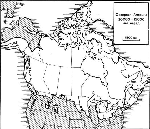
Rice. 63. Scheme of North American glacier melt at the end of the last ice age (mainly from the Geological Survey of Canada). A. North America 20,000-15,000 years ago
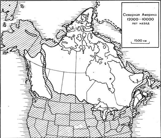
Rice. 63. Scheme of North American glacier melt at the end of the last ice age (mainly from the Geological Survey of Canada). B. About 12,000-10,000 years ago
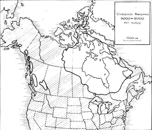
Rice. 63. Scheme of North American glacier melt at the end of the last ice age (mainly from the Geological Survey of Canada). B. About 9,000 years ago
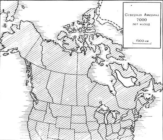
Rice. 63. Scheme of North American glacier melt at the end of the last ice age (mainly from the Geological Survey of Canada). D. About 7,000 years ago
Many attempts have been made to establish this cause and several hypotheses have been proposed, but none of them is generally accepted among scientists studying this problem. We will have to be content with a single hypothesis that explains the facts, although it has not yet been proven. This theory suggests that the amount of heat energy the Earth receives from the Sun changes in a slow pulsating manner, causing temperatures to constantly fluctuate within small limits. The idea is simple enough, but we don't yet have the means to prove it right or wrong. Having accepted this hypothesis for lack of a better one, we can assert that during the predominance of lowlands and vast seas (say, during the Cretaceous period), only very few glaciers (or none at all) could exist on Earth, and, consequently, the supposed slow pulsations of thermal The energy coming to the Earth's surface could only have a weak effect on the climate. But at a time (suppose, in the Cenozoic), when there were uplands and numerous mountainous areas, and a significant part of the area of \u200b\u200bthe continents was at fairly high latitudes, many glaciers could exist on the uplands. In this case, the pulsation, which at least slightly lowered the temperature, could lead to a catastrophic increase in the area of glaciers. Conversely, a small increase in temperature could have the opposite, but equally disastrous, result. We cannot say more yet.
The impact of glaciers on the Earth's surface
Glacial erosion. Mapping of ancient glaciers is possible mainly because moving ice leaves noticeable traces on the surface on which it moves. The ice scrapes, polishes, and in various other ways destroys the surface, and then it deposits the products of the destruction of the rocks. As a result, it is often possible to see how loose glacier sediment products lie on a surface eroded by a glacier, separated from it by a sharp boundary. Both the rocky surface and the deposits lying on it bear distinct, in most cases easily recognizable traces of the former presence of a glacier.
Fragments of rock of various sizes, picked up by moving ice, freeze into the lower surface of the ice and, like sand particles on sandpaper, scrape and scratch the rocky surface, leaving many intermittent furrows and scratches on the glacier bed (photo 51), which are completely different from traces, left behind by streams. In places, whole blocks of rock are separated along cracks from the bedrock and are carried away by the glacier, increasing the number of fragments that have frozen into the base of the glacier.
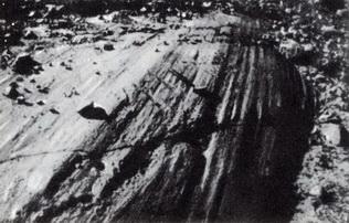
Photo 51. Glacial strokes and scratches on the surface of sandstones. The wreckage was left behind by a glacier moving away from the camera
Glacial accumulation. Fragments of rocks included in the ice are carried by it and deposited along the path of the glacier, forming a layer of sediments, which in some places, closer to the edge of the glacier, can reach considerable thickness. Since ice is a solid body, the deposition of debris by ice is completely different from that of a river. In a river, particles are deposited according to their size. The deposition of clastic material at the base of the glacier occurs in the same order as during the transfer, that is, without any sorting, coarse particles mixed with fine ones, boulders next to silty particles (photo 52). The resulting deposits often look like a pile of soil that has been bulldozed. In addition, unlike rounded river pebbles, which are overturned and rolled over by the stream, rock fragments in glacial deposits retain an irregular shape and have flat edges formed when a fragment frozen into the base of a glacier rubs against the rocky surface (photo 53).
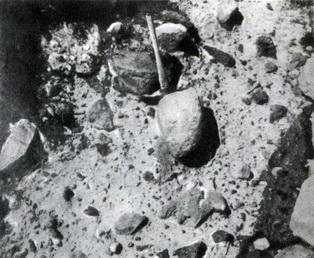
Photo 52. Clastic deposits from the time of the last glaciation, consisting of unrounded rock fragments of various sizes, unsorted and unstratified. These features distinguish them from water sediments. The handle of the ice ax is 45 cm long. North slope of Mount Rainier, Washington
In some places along and near the outer edge of the glacier, the deposited debris is displaced by water as the glacier melts. In such places, this material loses its typically glacial character and acquires sorting and layering as a result of processing by flowing waters. In this case, a series of layered deposits are randomly interspersed with strata of non-layered material.
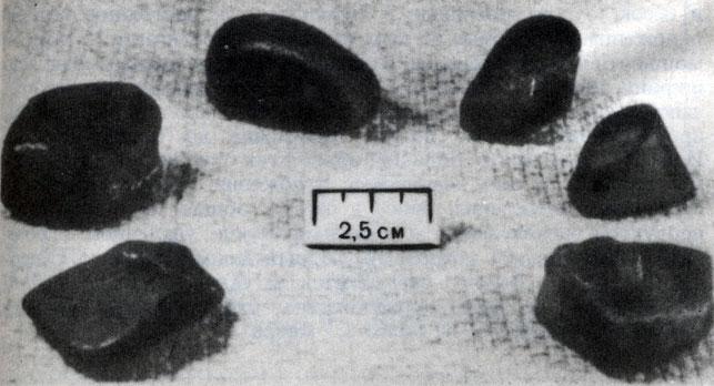
Photo 53 Six pebbles randomly selected from glacial deposits in New York State. Each pebble has one or more flat edges smoothed by a glacier
But whether or not they contain layered material, in general glacial deposits tend to form large or small ridges along the edge of the glacier. Such a ridge is a terminal moraine, a characteristic shape created by glaciation. In some areas, several moraines are observed, located one after another, each of which fixes the position of the edge of the glacier at the time of its deposition.
Streams of meltwater flowing from under the edge of the glacier, marked by a terminal moraine, deposited in their valleys pebbles and sand, sorted and layered, like real river sediments. Some of these deposits are up to 30 meters thick or even more, and spread across the entire width of the valley. Many sand-pebble deposits along the valleys of the Ohio or Mississippi rivers, traced along the Mississippi valley to the very delta, have a glacial origin. And yet, despite the large volume of these deposits, even if we add to them the glacial deposits distributed in the glacial boundaries, further north, the total thickness of the layer of weathering products and bedrock removed by the huge ice sheets that once covered North America and Europe is surprisingly small. We do not know exactly, but we can assume that the average thickness of this layer is probably no more than 7.5 meters.
lake depressions. A more obvious result of the influence of the glacier, and in particular the great ice sheets, on the relief was the formation of large and small depressions, many of which filled with water and became lakes. On any good large-scale map of Canada, the United States, or northern Europe, you can see that most of the lakes are concentrated in areas of ancient glaciation. There are hundreds of thousands of lakes in North America alone.
Depressions are created by the glacier in several ways. Some are formed as a result of partial removal of fractured bedrock by moving ice. Others are depressions in the uneven surface of glacial deposits. Still others are river valleys dammed by glacial deposits. (The Great Lakes of America have this origin, at least in part.) Many shallow basins were formed as a result of the melting of ice blocks ranging in size from several meters to tens of kilometers across, which were buried under glacial deposits. When such a block thaws, a depression is formed, into which sediments that previously lay on the ice sink. Among the many thousands of lakes in Minnesota, many are of this origin.
Weaker climate fluctuations
Climate after 1800 Temperature measurements taken by government agencies in most countries show temperature changes since the beginning of the 19th century. In the most general form, these changes are shown in the curve of Figure 64. It indicates that over the past hundred years, the average annual temperatures have increased by more than half a degree Celsius, and this increase has been uneven. It affected most of the planet, both tropical and high latitudes, both the northern and southern hemispheres. Then, after 1940, a cooling period began. Temperatures dropped, and by 1970 they reached the level that was observed around 1920. Thus, the fact is established that the climates of the Earth are not something constant and unchanged, but are subject to significant changes. The warm winters and hot summers that occurred in the 1930s in the western United States appear to be part of a general warming of the climate on a large scale.
Not surprisingly, the record of fluctuations in the size of small glaciers in the mountains of North America and in the Alps shows similarities with the temperature curve (Fig. 64). Measurements carried out on the same glaciers over a number of years show that between the end of the 19th century. and the middle of the 20th century. many glaciers have generally shrunk. But from around 1950, some glaciers began to increase again. Their regime reflects a change in trend, which is established by the temperature curve, but so far too little time has passed to be able to judge whether the direction of glacier development has changed.
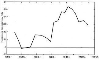
Rice. 64. Curve of temperature fluctuations (averaged for periods of five years)
Climate for the last 1000 years. Temperature measurements with the thermometer began to be made only shortly before the beginning of the 18th century, but a general idea of temperature fluctuations on a large scale in Europe, as well as in Japan over the past thousand years, can be obtained using various indirect methods. Various data show that approximately from the 11th to the 13th centuries. the climate has been warmer than at any time since then. This was the "Viking period" - a time when the summers were so warm and dry and when the northern seas were so free of floating ice that the Norwegians could sail everywhere in small boats. They even established colonies of 3,000 people or more in the south of Greenland, which traded agricultural products with Europe. However, after about 1500, trade ceased and communication with Europe was almost interrupted. The colonies were isolated, and in the XVIII century. the ship that arrived there did not find the descendants of the settlers of this once prosperous colony.
Carried out in the XX century. archaeological research of one hundred burials in the cemetery of one of the colonies helped to restore part of the later history of the colony. The soil at the burial site was frozen, as it is now in most Arctic regions, although it is clear that at the time of the burial, it was not frozen. The remains belonged to young people, which indicates a short life expectancy, small stature, which, combined with the deformation of the skeletons and unusually badly decayed teeth, suggests poor nutrition. It is likely that these people died from disease, starvation and other causes resulting from a long gradual deterioration of the climate.
After the "Viking period" and until the XVII century. throughout Europe there was a general drop in temperature. In Norway and the Alps, the inhabitants of the mountain villages were forced to retreat before the advancing glaciers. The lower limit of woody vegetation in the Alps also gradually decreased, yields ceased, and vineyards in the mountains of Germany were abandoned. Winters have become longer and colder. Anyone who has looked closely at 17th-century Dutch landscapes will remember that many of them depict winter scenes of people skating on frozen canals. You don't see that often these days.
Summarizing the above, it can be noted that the record of climate change over the past thousand years includes both the early "Viking period", which was warmer than the modern one, and the later cold period, which was colder than the modern one. The warming at the beginning of this century marked the end of this very cold period. On the whole, the given data confirm climate variability.
Last 10,000 years. In Sweden, Finland and other northern countries, vegetation is distributed in clearly defined zones, which are mainly determined by temperature (recall Fig. 35). The territory of these countries is dotted with lake depressions created by the great glaciers of the past, as described above. The age of almost all depressions is younger than 15,000 years, and many are younger than 10,000 years (Fig. 63). Some lakes were completely filled with sediments, mainly plant remains in the form of peat, and turned into swamps. Others, although still lakes, are gradually filled with peat. The deposits include not only plant stems and leaves, but also a large amount of pollen from plants growing around the lake.
Scientists assumed that by drilling a hole in the peat deposits that fill a swamp or lake, and identifying the plants found in each layer, they could reconstruct in detail the change of vegetation that surrounded the lake (Fig. 65). The change in the composition of vegetation during the transition from one layer to another should have reflected climate change, which began with the melting of the glacier. They expected that the vegetation would change from tundra in the lower horizons (represented by arctic grasses and shrubs growing near the glacier) to modern woody vegetation in the upper part of the section.
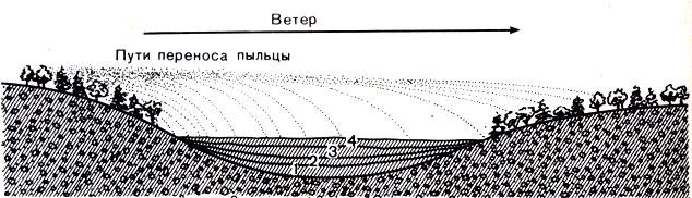
Rice. 65. A swamp that occupies a depression in glacial deposits, in which pollen from plants growing in the vicinity is deposited annually. Gradually, layers of fallen leaves, stems and other plant residues accumulate in it, forming peat.
After doing this experiment, scientists discovered and identified fossil plants (mainly by pollen), but were surprised by the change in vegetation from the bottom up. The vegetation changed from tundra to spruce and fir forests, then to birch and pine forests and on to oak, beech, alder and hazel, thus showing gradual warming. But higher, in the upper layers, these plants were again replaced by birch and pine, which mainly grow here at the present time. Oak, beech and hazel now grow much further south. However, radiocarbon dating of the layer containing oak, beech and hazel shows that this layer was formed about 5000 years ago.
In this case, it is obvious that the warmest climate was about 5000 years ago (3000 BC). At that time, the average temperatures were higher than modern (at the same points) by about 1 ° C. Then the trend of climate change reversed, the climate became wetter and the sky colder, the oak trees surrounding the swamp died and were replaced by birch and pine. Thus, we have received one more reliable evidence of climate fluctuations; instead of getting gradually warmer since the beginning of the glacier melt during the great glaciation, the climate 5,000 years ago became drier and warmer than it is today. At that time, glaciers in the Alps and Rocky Mountains were less numerous and smaller in size. Many of today's glaciers began to form less than 5,000 years ago and are thus "modern" glaciers and not remnants of glaciers from the last ice age ( Changes in climate and the size of glaciers occur continuously. Cooling and an increase in glaciers were in the XVIII - early XIX centuries. ("Little Ice Age"), in the 40-60s of the XIX century. (minor), warming in the 1920s-1940s, in the 1970s (minor). - Approx. ed).
Future
Scientists who study climate history are often asked two questions. The first of them: "Will there be a new glaciation?", and the second: "If there is, then when?" The first question is the easiest to answer. Most scientists agree to say "Yes, probably" because there have already been several glaciations in the last two million years, and the main conditions necessary for the occurrence of glaciation are land elevation, numerous mountains and the presence of a vast ice sheet at the South Pole. - still exist.
The answer to the second question is much less clear. The information we have about climates is still not accurate enough to judge whether there is a clear pattern in the frequency of glaciations. If we knew that such a pattern exists, and if we could measure the intervals between past glaciations, then we could predict what the climate of the future holds for us. Perhaps such a prediction will become possible in the future, but at present it is impossible.
Literature
Flint R. F. 1971, Glacial and Quaternary geology: John Wiley & Sons, New York. There is a Russian translation: Flint RF., Glaciers and Pleistocene Paleogeography, Moscow, IL, 1963.
Hovgaard William, 1925, The Norsemen in Greenland: "Georg. Rev.", v. 15, p. 605-616.
Lamb H. H., 1965, The early medieval warm epoch and its sequel: Palaeogeography, Palaeoclimatology, Palaeoecology, v. 1, p. 13-37.
Pjst Austin, LaChapelle E. R., 1971, Glacier ice: The Mountaineers: University of Washington Press, Seattle.
Schwarzbach Martin, 1963, Climates of the past: D. Van Nostrand Company, Princeton, N. J. There is a Russian translation: Schwarzbach M., Climates of the past, M., IL, 1955.