GEOLOGY
the science of the structure and history of the development of the Earth. The main objects of research are rocks, in which the geological record of the Earth is imprinted, as well as modern physical processes and mechanisms acting both on its surface and in the bowels, the study of which allows us to understand how our planet developed in the past. The earth is constantly changing. Some changes occur suddenly and very rapidly (for example, volcanic eruptions, earthquakes or large floods), but most often they occur slowly (a layer of precipitation no more than 30 cm thick is demolished or accumulated over a century). Such changes are not noticeable during the life of one person, but some information has been accumulated about changes over a long period of time, and with the help of regular accurate measurements, even insignificant movements of the earth's crust are recorded. For example, it has been established in this way that the area around the Great Lakes (USA and Canada) and the Gulf of Bothnia (Sweden) is currently rising, while the east coast of Great Britain is sinking and flooding. However, much more meaningful information about these changes lies in the rocks themselves, which are not just a collection of minerals, but pages of the Earth's biography that can be read if you know the language in which they are written. This chronicle of the Earth is very long. The history of the Earth began simultaneously with the development of the solar system about 4.6 billion years ago. However, the geological record is characterized by fragmentation and incompleteness, since many ancient rocks have been destroyed or overlain by younger sediments. Gaps need to be filled by correlation with events that have occurred elsewhere and for which more data are available, as well as by analogy and hypotheses. The relative age of rocks is determined on the basis of the complexes of fossil remains contained in them, and the deposits in which such remains are absent, on the basis of the relative position of both. In addition, the absolute age of almost all rocks can be determined by geochemical methods.
see also RADIOCARBON DATING.
Geological disciplines. Geology emerged as an independent science in the 18th century. Modern geology is divided into a number of closely related branches. These include: geophysics, geochemistry, historical geology, mineralogy, petrology, structural geology, tectonics, stratigraphy, geomorphology, paleontology, paleoecology, mineral geology. There are also several interdisciplinary fields of study: marine geology, engineering geology, hydrogeology, agricultural geology, and environmental geology (ecogeology). Geology is closely related to such sciences as hydrodynamics, oceanology, biology, physics and chemistry.
NATURE OF THE EARTH
Crust, mantle and core. Most of the information about the internal structure of the Earth is obtained indirectly based on the interpretation of the behavior of seismic waves that are recorded by seismographs. Two main boundaries have been established in the bowels of the Earth, at which there is a sharp change in the nature of the propagation of seismic waves. One of them, with a strong reflective and refractive power, is located at a depth of 13-90 km from the surface under the continents and 4-13 km - under the oceans. It is called the Mohorovichich boundary, or Moho surface (M), and is considered a geochemical boundary and a zone of phase transition of minerals under the influence of high pressure. This boundary separates the earth's crust and mantle. The second boundary is located at a depth of 2900 km from the Earth's surface and corresponds to the boundary between the mantle and the core (Fig. 1).
Temperatures. Based on the fact that molten lava erupts from volcanoes, it was believed that the bowels of the Earth are red-hot. According to the results of temperature measurements in mines and oil wells, it has been established that the temperature of the earth's crust continuously increases with depth. If this trend continued down to the core of the Earth, then its temperature would be approx. 2925°C, i.e. would significantly exceed the melting points of rocks commonly found on the earth's surface. However, based on data on the propagation of seismic waves, it is believed that most of the Earth's interior is in a solid state. The solution of the problem of the temperature of the Earth's interior, which is closely related to the early history of the Earth, is of great importance, but it still remains debatable. According to some theories, the Earth was initially hot and then cooled down, according to others, it was initially cold and then warmed up under the action of heat generated during the decay of radioactive elements and high pressure at depth.
Terrestrial magnetism. It is usually believed that the magnetic field is created inside the Earth, but the mechanism of its occurrence is not clear enough. The magnetic field cannot be the result of the permanent magnetization of the iron core of the Earth, since the temperature already at a depth of several tens of kilometers is well below the Curie point, the temperature at which matter loses its magnetic properties. In addition, the hypothesis of a permanent magnet in a fixed position contradicts the observed changes in the magnetic field now and in the past. Remanent magnetization is preserved in sedimentary and volcanic rocks. Particles of magnetite deposited in calm water bodies, as well as magnetic minerals in lava flows at temperatures below the Curie point, cool down and orient themselves in the direction of the lines of force of the local magnetic field that existed during the formation of the rocks. Paleomagnetic studies of rocks make it possible to establish the position of the magnetic poles that existed during sedimentation and affected the orientation of magnetic particles. The results obtained indicate that either the magnetic poles or parts of the earth's crust significantly changed their position with respect to the Earth's rotation axis over time (the former seems unlikely). There is also strong evidence that the continents moved relative to each other. For example, the positions of the magnetic pole determined from paleomagnetic data for rocks of the same age in North America, Europe, and Australia do not coincide spatially. These facts confirm the hypothesis that the continents formed from a single parent continent as a result of its division into separate parts and their subsequent separation.
see also GEOMAGNETISM.
Gravitational field of the Earth. Gravitational studies have established that the earth's crust and mantle bend under the influence of additional loads. For example, if the earth's crust everywhere had the same thickness and density, then one would expect that in the mountains (where the mass of rocks is greater) a greater force of attraction would act than on the plains or in the seas. However, from about the middle of the 18th century. it has been noticed that the gravitational attraction in and near mountains is less than expected (assuming that mountains are simply additional mass of the earth's crust). This fact was explained by the presence of "voids", which were interpreted as rocks decompacted during heating or as a salt core of mountains. Such explanations proved untenable, and two new hypotheses were proposed in the 1850s. According to the first hypothesis, the earth's crust consists of blocks of rocks of different sizes and densities, floating in a denser environment. The bases of all blocks are at the same level, and blocks with low density should be higher than blocks with high density. Mountain structures were taken as blocks of low density, and oceanic basins - high (with the same total mass of both). According to the second hypothesis, the density of all blocks is the same and they float in a denser medium, and the different surface heights are explained by their different thicknesses. It is known as the mountain roots hypothesis, since the higher the block, the deeper it is submerged in the host environment. In the 1940s, seismic data were obtained confirming the idea of thickening of the earth's crust in mountainous areas.
Isostasy. Whenever an additional load is applied to the earth's surface (for example, as a result of sedimentation, volcanism, or glaciation), the earth's crust sags and subsides, and when this load is removed (as a result of denudation, melting ice sheets, etc.), the earth's crust rises. This compensatory process, known as isostasy, is likely realized through horizontal mass transfer within the mantle, where intermittent melting of material can occur. It has been established that some parts of the coast of Sweden and Finland have risen by more than 240 m over the past 9000 years, mainly due to the melting of the ice sheet. The uplifted shores of the Great Lakes in North America also formed as a result of isostasy. Despite the operation of such compensatory mechanisms, large oceanic troughs and some deltas show a significant mass deficit, while some areas of India and Cyprus show a significant excess of it.
Volcanism. Origin of lava. In some parts of the world, magma erupts onto the earth's surface in the form of lava during volcanic eruptions. Many volcanic island arcs appear to be associated with deep fault systems. Earthquake centers are located approximately at a depth of up to 700 km from the level of the earth's surface, i.e. volcanic material comes from the upper mantle. On island arcs, it often has an andesitic composition, and since andesites are similar in composition to the continental crust, many geologists believe that the continental crust in these areas builds up due to the input of mantle matter. Volcanoes that act along oceanic ridges (for example, the Hawaiian one) erupt material of a predominantly basaltic composition. These volcanoes are probably associated with shallow earthquakes, the depth of which does not exceed 70 km. Since basalt lavas occur both on continents and along oceanic ridges, some geologists suggest that there is a layer directly below the earth's crust from which basaltic lavas come.
see also VOLCANOES. However, it is not clear why both andesites and basalts are formed from the mantle matter in some areas, and only basalts in others. If, as is now believed, the mantle is indeed ultramafic (i.e., enriched in iron and magnesium), then mantle-derived lavas must be basaltic rather than andesitic in composition, since andesite minerals are absent from ultramafic rocks. This contradiction is resolved by the theory of plate tectonics, according to which the oceanic crust moves under island arcs and melts at a certain depth. These molten rocks are poured out in the form of andesitic lavas.
Heat sources. One of the unsolved problems of manifestation of volcanic activity is the determination of the heat source necessary for the local melting of the basalt layer or mantle. Such melting must be highly localized, since the passage of seismic waves shows that the crust and upper mantle are usually in a solid state. Moreover, the thermal energy must be sufficient to melt huge volumes of solid material. For example, in the United States, in the Columbia River basin (Washington and Oregon), the volume of basalts is more than 820 thousand km3; similar large strata of basalts are found in Argentina (Patagonia), India (Decan Plateau) and South Africa (Great Karoo Rise). There are currently three hypotheses. Some geologists believe that the melting is due to local high concentrations of radioactive elements, but such concentrations in nature seem unlikely; others suggest that tectonic disturbances in the form of shifts and faults are accompanied by the release of thermal energy. There is another point of view, according to which the upper mantle is in a solid state under conditions of high pressures, and when the pressure drops due to cracking, it melts and liquid lava flows out of the cracks.
Geochemistry and composition of the Earth. Determining the chemical composition of the Earth is a difficult task, since the core, mantle, and most of the crust are inaccessible for direct sampling and observation, and conclusions have to be drawn on the basis of interpretation of indirect data and analogies.
Earth is like a giant meteorite. It is assumed that meteorites are fragments of pre-existing planets, which in their composition and structure resembled the Earth. There are several types of meteorites. The best known and fairly common are iron meteorites, consisting of metallic iron and iron-nickel alloys, which are believed to have formed the cores of existing planets and, by analogy, should be identical to the earth's core in density, composition and magnetic properties. The second type is stony meteorites, consisting mainly of iron-magnesian silicate minerals. They are more common than iron meteorites and in their density correspond to the rocks that make up the mantle. The composition of stony meteorites is very close to the ultramafic rocks of the Earth. The third type is mixed meteorites, containing metals and silicates, which indicates their genesis from the transitional (from the mantle to the core) layer of a pre-existing planet.
Density of the Earth. The average density of the Earth is 5.5 times the density of water, 5 times the density of Venus and 3.9 times that of Mars. It is estimated that the increase in density with depth, which is in good agreement with the Earth's total mass, moment of inertia, seismic properties and compressibility, is distributed as follows. The average density of the earth's crust (at least in its upper part to a depth of 32 km) is 3.32 g/cm3, below the surface of Mohorovich it continuously increases (this pattern is somewhat violated at the levels of 415 and 988 km). At a depth of 2900 km, there is a boundary between the mantle and the outer core, where there is a sharp jump in density from 5.68 to 9.57 g/cm3. From this mark and up to the border between the outer and inner core at a depth of 5080 km, the density continues to increase continuously (comprising 11.54 g/cm3 at a depth of 4830 km). The density of the inner core is estimated at 14 to 17 g/cm3.
The earth is like a giant blast furnace. Some geologists believe that if the Earth was once in a molten state, then it is likely that this molten material was divided into layers of different composition, similar to what happens in a blast furnace, when metal accumulates at the bottom, above - sulfides, and even higher - silicates. It is possible that the interior of the Earth is divided in the same sequence into a metal core and sulfide and silicate shells. However, no evidence of a sulfide layer was found.
The composition of the earth's crust. Most of the earth's crust is not accessible for study because it is overlain by younger sedimentary rocks, hidden by the waters of the seas and oceans, and even if it comes to the surface somewhere, sampling can be done from relatively small strata. Moreover, the diversity of rocks and minerals and the varying degree of their contribution to the structure of the Earth makes it difficult or impossible to obtain representative samples. Any quantitative indicators or averaged data on the chemical and mineralogical composition of the earth's crust represent a rough approximation to the true characteristic. With a greater or lesser degree of certainty, a general idea of the chemical composition of the earth's crust was compiled on the basis of the analysis of more than 5000 samples of igneous (igneous) rocks. It is established that 99% of it consists of 12 elements. Their participation in weight percent is distributed as follows: oxygen (46.6), silicon (27.7), aluminum (8.1), iron (5.0), calcium (3.6), sodium (2.8) , magnesium (2.6), titanium (2.1), manganese (0.4), phosphorus (0.1), sulfur and carbon (together less than 0.1). Obviously, the earth's crust is dominated by oxygen, so the 10 most common metals are present in the form of oxides. However, usually the minerals that make up the rocks are not simple, but complex oxides, which include several metals. Because silicon is one of the most abundant elements on Earth, many minerals are complex silicates of various kinds. The combination of minerals in different quantitative proportions forms a variety of rocks.
The chemical composition of the atmosphere. The present atmosphere is the result of the slow and prolonged loss, through volcanic activity and other processes, of the original Earth's atmosphere. Approximately 3.1-2.7 billion years ago, with the beginning of the release of large amounts of carbon dioxide and water vapor, conditions appeared for the life of the first plants that carry out the process of photosynthesis. Large quantities of oxygen released into the atmosphere by plants were first used for the oxidation of metals, as evidenced by the wide distribution of Precambrian iron ores on the globe. 1.6 billion years ago, the content of free oxygen in the atmosphere reached about 1% of its current amount, which allowed the birth of primitive animal organisms. Apparently, the primordial atmosphere had a reducing character, while the modern, secondary, atmosphere is characterized by oxidizing properties. Gradually, its chemical composition changed due to ongoing volcanic activity and the evolution of the organic world.
The chemical composition of the oceans. It is assumed that initially there was no water on Earth. In all likelihood, modern waters on the Earth's surface are of secondary origin, i.e. were released as vapor from the minerals of the earth's crust and mantle as a result of volcanic activity, and were not formed by the combination of free oxygen and hydrogen molecules. If seawater were gradually accumulating, then the volume of the World Ocean would have to increase continuously, but there is no direct geological evidence of this circumstance; this means that oceans have existed throughout the Earth's geological history. The change in the chemical composition of oceanic waters occurred gradually.
Sial and Sima. There is a difference between the crustal rocks that underlie the continents and the rocks that lie beneath the ocean floor. The composition of the continental crust corresponds to granodiorite, i.e. rock, consisting of potassium and sodium feldspar, quartz and small amounts of iron-magnesian minerals. The oceanic crust corresponds to basalts composed of calcium feldspar, olivine, and pyroxene. The rocks of the continental crust are characterized by a light color, low density and usually acidic composition, they are often called sial (by the predominance of Si and Al). The rocks of the oceanic crust are distinguished by their dark color, high density and basic composition, they are called sima (according to the predominance of Si and Mg). The mantle rocks are believed to be ultramafic in composition and consist of olivine and pyroxene. In modern Russian scientific literature, the terms "sial" and "sima" are not used, because considered obsolete.
GEOLOGICAL PROCESSES
Geological processes are divided into exogenous (destructive and accumulative) and endogenous (tectonic).
DESTRUCTIVE PROCESSES
Denudation. The action of watercourses, wind, glaciers, sea waves, frost weathering and chemical dissolution lead to the destruction and reduction of the surface of the continents (Fig. 2). The products of destruction under the action of gravitational forces are carried to the oceanic depressions, where they accumulate. Thus, the composition and density of the rocks that make up the continents and ocean basins are averaged, and the amplitude of the Earth's relief decreases.
Every year, 32.5 billion tons of detrital material and 4.85 billion tons of dissolved salts are removed from the continents and deposited in the seas and oceans, as a result of which approximately 13.5 km3 of sea water is displaced. If such rates of denudation had continued in the future, the continents (the volume of the above-water part of which is 126.6 million km3) in 9 million years would have turned into almost flat plains - peneplens. Such a peneplanization (leveling) of the relief is possible only theoretically. In fact, isostatic uplifts compensate for losses due to denudation, and some rocks are so strong that they are practically indestructible. Continental deposits are redistributed as a result of the combined action of weathering (destruction of rocks), denudation (mechanical demolition of rocks under the influence of flowing waters, glaciers, wind and wave processes) and accumulation (deposits of loose material and the formation of new rocks). All these processes operate only up to a certain level (usually sea level), which is considered as the basis of erosion. During transportation, loose sludge is sorted by size, shape and density. As a result, quartz, the content of which in the original rock can be only a few percent, forms a homogeneous stratum of quartz sands. Similarly, particles of gold and some other heavy minerals, such as tin and titanium, are concentrated in stream channels or shallows and form alluvial deposits, while fine-grained material is deposited as silts and then converted into shale. Components such as magnesium, sodium, calcium and potassium, for example, are dissolved and carried away by surface and ground water, and then deposited in caves and other cavities or enter sea water.
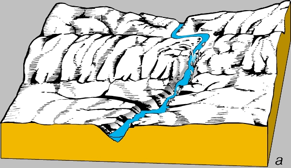
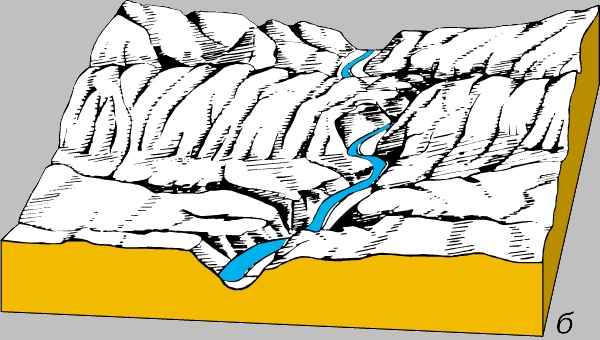
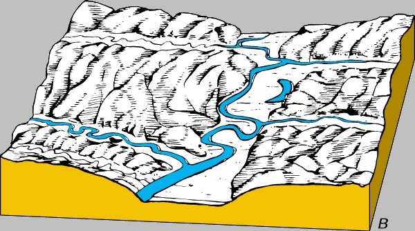
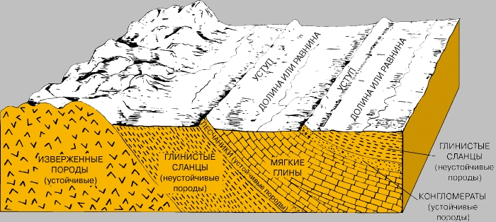
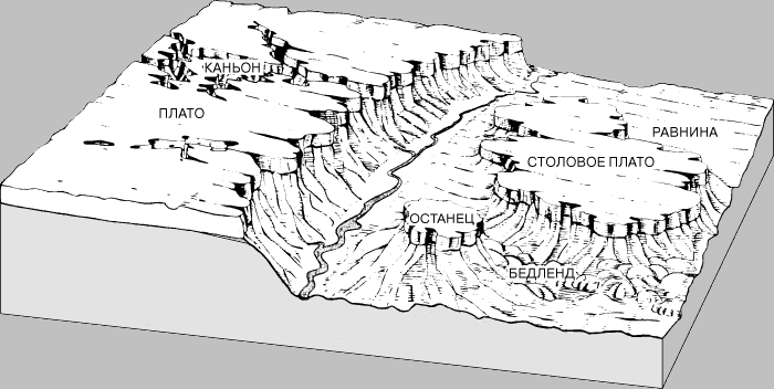
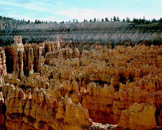
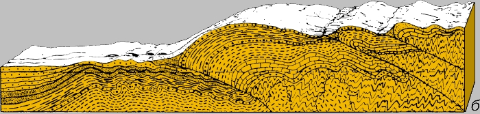
Stages of development of erosional relief. The relief serves as an indicator of the stage of leveling (or peneplanization) of the continents. In mountains and areas that have experienced intense uplift, erosion processes are most active. Such areas are characterized by a rapid incision of river valleys and an increase in their length in the upper reaches, and the landscape corresponds to a young, or young, stage of erosion. In other areas, where the amplitude of heights is small and erosion has largely ceased, large rivers mainly carry entrained and suspended sediments. Such a relief is inherent in the mature stage of erosion. In areas with small height amplitudes, where the land surface slightly exceeds sea level, accumulative processes predominate. There, the river usually flows somewhat above the general level of the low plain in a natural elevation composed of sedimentary material, and forms a delta in the estuarine zone. This is the oldest erosional relief. However, not all areas are at the same stage of erosion development and have the same appearance. Relief forms vary greatly depending on climatic and weather conditions, the composition and structure of local rocks, and the nature of the erosion process (Fig. 3, 4).
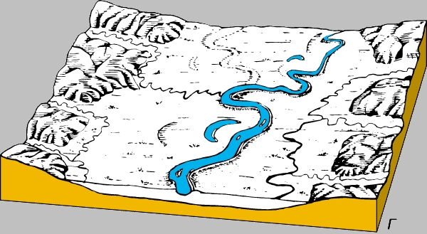
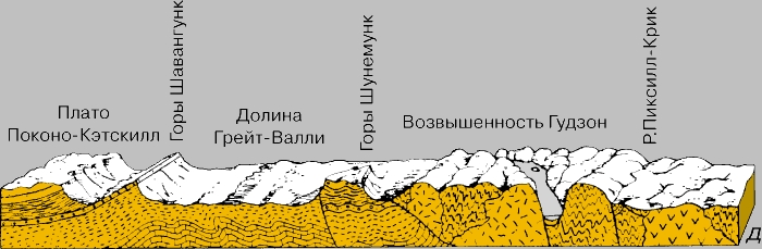
Breaks in erosion cycles. The noted sequence of erosion processes is valid for continents and oceanic basins that are in static conditions, but in fact they are subject to many dynamic processes. The erosion cycle can be interrupted by changes in sea level (for example, due to the melting of ice sheets) and the height of the continents (for example, as a result of mountain building, fault tectonics and volcanic activity). In Illinois (USA), the moraines covered the mature pre-glacial relief, giving it a typical young appearance. In the Grand Canyon of Colorado, a break in the erosion cycle was due to the rise of the land to the level of 2400 m. As the territory rose, the Colorado River gradually cut into its floodplain and turned out to be limited by the sides of the valley. As a result of this break, superimposed meanders were formed, which are characteristic of the ancient river valleys that exist in the conditions of a young relief (Fig. 5). Within the Colorado Plateau, the meanders are cut to a depth of 1200 m. The deep meanders of the Susquehanna River, which cut through the Appalachian Mountains, also indicate that this area was once a lowland that was crossed by a "decrepit" river.

ACCUMULATOR PROCESSES
Sedimentation is one of the most important geological processes, as a result of which new rocks are formed. Material carried off the land eventually accumulates in the seas and oceans, where strata of sand, silt and clay are formed. Typically, silt and argillaceous deposits are deposited on the seafloor farther from the shore. With the subsequent uplift of these areas, they are transformed into clay shales. The sands are deposited predominantly on beaches and are eventually converted into sandstones. If the destruction products are not sorted, then over time they turn into conglomerates. Chemical compounds carried in solutions replenish the reserves of substances necessary for the life of marine plants and animals. For example, calcium is used to build calcareous shells and shells, and together with phosphorus, to build bones and teeth of animals; iron takes part in hematopoiesis in fish and other animals, and cobalt is a component of vitamin B12. When animals die, their shells and skeletons, composed of calcium carbonate, settle on the seabed, and when the territory is subsequently raised, they are exposed as limestone strata. In addition, chemicals can be directly deposited when seawater evaporates. It is in this way that salt deposits are formed. If organic matter accumulates in continental conditions, coal deposits are formed, and in marine conditions, oil is formed. For the most part, this kind of sedimentation occurs on the continental margins and entails an increase in their areas due to the growth of deltas, shelves and reefs. It is under these conditions that biogenic carbonate sediments are formed. Since the main part of the demolished material settles just in the zone of coastal shallow water, this zone, with a slight decrease in sea level, may turn out to be in subaerial conditions. Only an insignificant part of clastic terrigenous material is carried far beyond the shelf (Fig. 6).
TECTONICS
It has long been established that mountains are formed as a result of the formation of folds and faults and tectonic uplifts of sedimentary strata that accumulated at the bottom of the sea. In addition, there is a lot of evidence that the areas of the most intense tectonic disturbances are confined to the coastal zones of the seas, where the thickness of precipitation is greatest. Mountain building (orogeny) is one of the most important processes in the formation of the Earth's relief, as a result of which sedimentary strata, carried away from the continents, are again subjected to tectonic uplifts. Observations in modern mountainous areas indicate that several distinct stages can be distinguished in the development of the relief.
Formation of geosynclines. It is believed that mountain building begins with the accumulation of thick sedimentary strata in geosynclines - large elongated depressions in the earth's crust. Most of them experienced slow long-term subsidence (over 50-100 million years) and filling with sediments sometimes up to 9 km thick. It was established that the scales and rates of these processes varied greatly within the same basin and even had different directions: while one part of it was actively sinking, the other was in relatively stable conditions and no sediments accumulated there. A certain cyclicity can be traced in the formation of geosynclines and sedimentation: transgressions of the seas regularly alternated with regressions. Some mountainous countries consist of internal ranges composed of folded sedimentary strata, and parallel external ranges, composed mainly of volcanic rocks. It is possible that these ranges were formed in different geosynclinal basins, but were interconnected. Depressions with sedimentary rocks are called miogeosynclines, and those with volcanic rocks are called eugeosynclines. The mutual position of these two types was constant: the eugeosynclines faced the sea, while the miogeosynclines were located between the eugeosynclines and the land. Usually, mountain building processes first covered eugeosynclines, and then miogeosynclines. The Washington and Oregon Coast Ranges and the Sierra Nevada Mountains of California corresponded to the eugeosynclinal zone. Appalachians, New England mountains (including White Mountains) and Piedmont have the same genesis. On the contrary, the Rocky Mountains within Montana, Wyoming and Colorado, as well as the Valleys and Ranges zone in Pennsylvania and Tennessee, were associated with miogeocyclines.
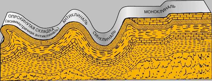
Geosyncline transformation. At certain stages of development in geosynclines, the formation of folds and faults occurs, and the filling sediments are metamorphosed under the influence of high temperatures and pressures. Processes of compression directed at a right angle to the axis of the depressions are manifested, which is accompanied by deformations of the sedimentary strata.
Modern geosynclines are depressions along the islands of Java and Sumatra, the troughs of Tonga - Kermadec, Puerto Rico, etc. Perhaps their further subsidence will also lead to the formation of mountains. According to many geologists, the coast of the Gulf of Mexico within the United States also represents a modern geosyncline, although, judging by the drilling data, signs of mountain building are not expressed there. Active manifestations of modern tectonics and mountain building are most clearly observed in young mountainous countries - the Alps, the Andes, the Himalayas and the Rocky Mountains.
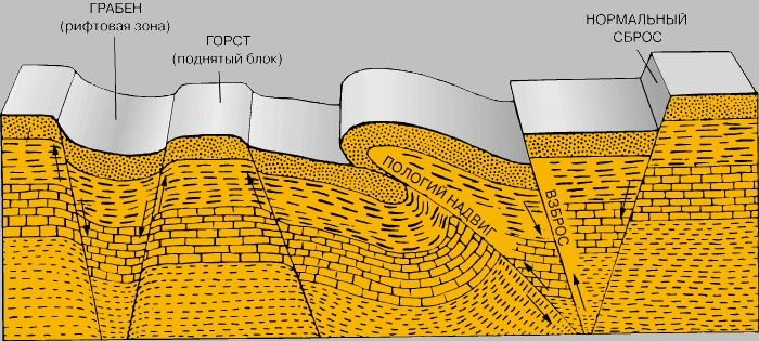
Tectonic uplifts. At the final stages of the development of geosynclines, when mountain building is completed, an intensive general uplift of the continents occurs; within mountainous countries at this stage of relief formation, disjunctive dislocations occur (displacement of individual blocks of rocks along fault lines).
GEOLOGICAL TIME
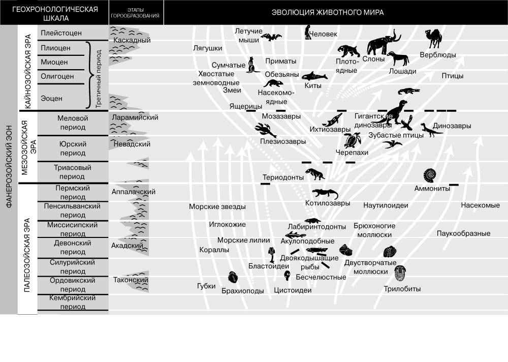
Stratigraphic scale. The standard geologic time scale (or geologic column) is the result of a systematic study of sedimentary rocks in different regions of the globe. Since most of the early work was carried out in Europe, the stratigraphic sequence of deposits in this region was taken as a reference for other areas. However, for various reasons, this scale has shortcomings and gaps, so it is constantly updated. The scale is very detailed for younger geological periods, but its detail is significantly reduced for older ones. This is inevitable, since the geological record is most complete for events of the recent past and becomes more fragmented with increasing age of the deposits. The stratigraphic scale is based on the consideration of fossil organisms, which serve as the only reliable criterion for interregional correlations (especially distant ones). It has been established that some fossils correspond to a strictly defined time and are therefore considered guiding. The rocks containing these leading forms and their complexes occupy a strictly defined stratigraphic position. It is much more difficult to make correlations for paleontologically silent rocks that do not contain fossils. Since well-preserved shells are found only from the Cambrian period (about 570 million years ago), the Precambrian time, covering approx. 85% of geological history cannot be studied and subdivided in the same detail as younger eras. For interregional correlations of paleontologically silent rocks, geochemical dating methods are used. If necessary, changes were made to the standard stratigraphic scale to reflect regional specifics. For example, in Europe there is a Carboniferous period, and in the USA two correspond to it - Mississippi and Pennsylvania. Difficulties arise everywhere in correlating local stratigraphic schemes with the international geochronological scale. The International Commission on Stratigraphy helps address these issues and sets standards for stratigraphic nomenclature. She strongly recommends using local stratigraphic units in geological surveys and comparing them with the international geochronological scale for comparison. Some fossils have a very wide, almost global distribution, while others are narrowly regional. Eras are the largest divisions of the Earth's history. Each of them combines several periods characterized by the development of certain classes of ancient organisms. Mass extinction of various groups of organisms occurred at the end of each era. For example, trilobites disappeared at the end of the Paleozoic, and dinosaurs at the end of the Mesozoic. The causes of these disasters have not yet been elucidated. These could be critical stages in genetic evolution, peaks in cosmic radiation, emissions of volcanic gases and ash, as well as very abrupt climate changes. There are arguments in support of each of these hypotheses. However, the gradual disappearance of a large number of families and classes of animals and plants by the end of each era and the appearance of new ones with the beginning of the next era still remains one of the mysteries of geology. Attempts to connect the mass death of animals at the final stages of the Paleozoic and Mesozoic with global cycles of mountain building were unsuccessful.
Geochronology and absolute age scale. The stratigraphic scale reflects only the sequence of rock stratification and therefore can only be used to indicate the relative age of different layers (Fig. 9). The possibility of establishing the absolute age of rocks appeared after the discovery of radioactivity. Prior to this, attempts were made to estimate the absolute age by other methods, for example, by analyzing the salt content in sea water. Assuming that it corresponds to the solid runoff of the world's rivers, the minimum age of the seas can be measured. Based on the assumption that initially the ocean water did not contain salt impurities, and taking into account the rate of their entry, the age of the seas was estimated in a wide range - from 20 million to 200 million years. Kelvin estimated the age of the rocks that make up the Earth at 100 million years, because, in his opinion, it took so long for the initially molten Earth to cool to its current surface temperature.
Apart from these attempts, early geologists were content with determining the relative age of rocks and geological events. Without any explanation, it was assumed that quite a long time had passed from the moment the Earth appeared to the formation of various types of sediments as a result of processes that are still operating today. And only when scientists began to measure the rate of radioactive decay, geologists got "clocks" to determine the absolute and relative age of rocks containing radioactive elements. The rates of radioactive decay of some elements are negligible. This makes it possible to determine the age of ancient events by measuring the content of such elements and their decay products in a particular sample. Since the rate of radioactive decay does not depend on environmental parameters, it is possible to determine the age of rocks located in any geological conditions. The most commonly used uranium-lead and potassium-argon methods. The uranium-lead method allows accurate dating based on measurements of the concentration of radioisotopes of thorium (232Th) and uranium (235U and 238U). During radioactive decay, isotopes of lead (208Pb, 207Pb and 206Pb) are formed. However, rocks containing these elements in sufficient quantities are quite rare. The potassium-argon method is based on a very slow radioactive transformation of the 40K isotope into 40Ar, which makes it possible to date events that are several billion years old by the ratio of these isotopes in the rocks. A significant advantage of the potassium-argon method is that potassium, a very common element, is present in minerals formed in all geological settings - volcanic, metamorphic and sedimentary. However, the inert gas argon resulting from radioactive decay is not chemically bound and leaks. Consequently, only those minerals in which it is well retained can be reliably used for dating. Despite this shortcoming, the potassium-argon method is widely used. The absolute age of the most ancient rocks on the planet is 3.5 billion years. Very ancient rocks are represented in the earth's crust of all continents, so the question of which of them is the oldest does not even arise. The age of meteorites that fell to the Earth, according to the potassium-argon and uranium-lead methods, is approximately 4.5 billion years. According to geophysicists, based on the data of the uranium-lead method, the Earth also has an age of approx. 4.5 billion years. If these estimates are correct, then there is a gap of 1 billion years in the geological record, corresponding to an important early stage in the evolution of the Earth. Perhaps the earliest evidence was destroyed or erased in some way while the Earth was in a molten state. It is also quite probable that the most ancient rocks of the Earth were denuded or recrystallized over many millions of years.
HISTORICAL GEOLOGY
Archean era. The most ancient rocks exposed on the surface of the continents were formed in the Archean era. Recognition of these rocks is difficult, since their outcrops are dispersed and in most cases are covered by thick strata of younger rocks. Where these rocks are exposed, they are so metamorphosed that it is often impossible to restore their original character. During numerous long stages of denudation, thick strata of these rocks were destroyed, and the remaining ones contain very few fossil organisms and therefore their correlation is difficult or even impossible. It is interesting to note that the oldest known Archean rocks are probably highly metamorphosed sedimentary rocks, while the older rocks overlain by them were melted and destroyed by numerous igneous intrusions. Therefore, traces of the primary earth's crust have not yet been discovered. There are two large areas of outcrops of Archean rocks in North America. The first of them - the Canadian Shield - is located in central Canada on both sides of the Hudson Bay. Although in places the Archean rocks are overlain by younger ones, they form the day surface in most of the territory of the Canadian Shield. The oldest known rocks in this area are represented by marbles, slates and crystalline schists interbedded with lavas. Initially, limestones and shales were deposited here, later sealed by lavas. Then these rocks experienced the impact of powerful tectonic movements, which were accompanied by large granite intrusions. Ultimately, the sedimentary rock strata underwent strong metamorphism. After a long period of denudation, these highly metamorphosed rocks were brought to the surface in places, but granites form the general background. Outcrops of Archean rocks are also found in the Rocky Mountains, where they form the crests of many ridges and individual peaks, such as Pikes Peak. The younger rocks there are destroyed by denudation. In Europe, Archean rocks are exposed on the territory of the Baltic Shield within Norway, Sweden, Finland and Russia. They are represented by granites and highly metamorphosed sedimentary rocks. Similar outcrops of Archean rocks are found in the south and southeast of Siberia, China, western Australia, Africa, and northeast South America. The oldest traces of the vital activity of bacteria and colonies of unicellular blue-green algae Collenia were found in the Archean rocks of southern Africa (Zimbabwe) and the province of Ontario (Canada).
Proterozoic era. At the beginning of the Proterozoic, after a long period of denudation, the land was largely destroyed, some parts of the continents experienced subsidence and were flooded by shallow seas, and some low-lying basins began to be filled with continental deposits. In North America, the most significant exposures of Proterozoic rocks are found in four areas. The first of them is confined to the southern part of the Canadian Shield, where thick strata of shales and sandstones of the age under consideration are exposed around the lake. Upper and northeast of the lake. Huron. These rocks are of both marine and continental origin. Their distribution indicates that the position of the shallow seas changed significantly during the Proterozoic. In many places, marine and continental sediments are interbedded with thick lava sequences. At the end of sedimentation, tectonic movements of the earth's crust took place, the Proterozoic rocks underwent folding, and large mountain systems were formed. In the foothills east of the Appalachians, there are numerous outcrops of Proterozoic rocks. Initially, they were deposited in the form of layers of limestone and shale, and then during orogeny (mountain building) they metamorphosed and turned into marble, slate and crystalline schists. In the Grand Canyon area, a thick sequence of Proterozoic sandstones, shales, and limestones unconformably overlies Archean rocks. In the northern part of the Rocky Mountains, a sequence of Proterozoic limestones with a thickness of approx. 4600 m. Although the Proterozoic formations in these areas were affected by tectonic movements and were crumpled into folds and broken by faults, these movements were not intense enough and could not lead to rock metamorphism. Therefore, the original sedimentary textures were preserved there. In Europe, there are significant outcrops of Proterozoic rocks within the Baltic Shield. They are represented by highly metamorphosed marbles and slates. In the northwest of Scotland, a thick stratum of Proterozoic sandstones overlies Archean granites and crystalline schists. Extensive outcrops of Proterozoic rocks are found in western China, central Australia, southern Africa, and central South America. In Australia, these rocks are represented by a thick sequence of non-metamorphosed sandstones and shales, while in eastern Brazil and southern Venezuela, they are strongly metamorphosed slates and crystalline schists. Fossil blue-green algae Collenia are very widespread on all continents in non-metamorphosed limestones of the Proterozoic age, where a few fragments of shells of primitive mollusks have also been found. However, the remains of animals are very rare, and this indicates that most organisms were distinguished by a primitive structure and did not yet have hard shells that are preserved in a fossil state. Although traces of ice ages are recorded for the early stages of the history of the Earth, extensive glaciation, which had an almost global distribution, is noted only at the very end of the Proterozoic.
Palaeozoic. After the land experienced a long period of denudation at the end of the Proterozoic, some of its territories experienced subsidence and were inundated by shallow seas. As a result of the denudation of elevated areas, sedimentary material was carried by water flows into the geosyncline, where strata of Paleozoic sedimentary rocks with a thickness of more than 12 km accumulated. In North America, two large geosynclines formed at the beginning of the Paleozoic era. One of them, called the Appalachian, stretched from the northern part of the Atlantic Ocean through southeastern Canada and further south to the Gulf of Mexico along the axis of the modern Appalachians. Another geosyncline connected the Arctic Ocean with the Pacific, passing somewhat east of Alaska south through eastern British Columbia and western Alberta, then through eastern Nevada, western Utah and southern California. Thus North America was divided into three parts. In certain periods of the Paleozoic, its central regions were partly flooded and both geosynclines were connected by shallow seas. In other periods, as a result of isostatic uplifts of land or fluctuations in the level of the World Ocean, marine regressions occurred, and then terrigenous material was deposited in geosynclines washed out from adjacent elevated regions. In the Paleozoic, similar conditions existed on other continents. In Europe, huge seas periodically flooded the British Isles, the territories of Norway, Germany, France, Belgium and Spain, as well as a vast area of the East European Plain from the Baltic Sea to the Ural Mountains. There are also large outcrops of Paleozoic rocks in Siberia, China, and northern India. They are native to most parts of eastern Australia, northern Africa, and northern and central South America. The Paleozoic era is divided into six periods of unequal duration, alternating with short-term stages of isostatic uplifts or marine regressions, during which sedimentation did not occur within the continents (Fig. 9, 10).
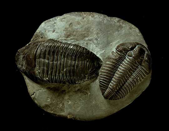
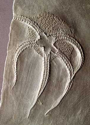
The Cambrian period is the earliest period of the Paleozoic era, named after the Latin name for Wales (Cambria), where rocks of this age were first studied. In North America, in the Cambrian, both geosynclines were flooded, and in the second half of the Cambrian, the central part of the mainland occupied such a low position that both troughs were connected by a shallow sea and layers of sandstones, shales, and limestones accumulated there. A major marine transgression was taking place in Europe and Asia. These parts of the world were largely flooded. The exceptions were three large isolated landmasses (the Baltic Shield, the Arabian Peninsula and southern India) and a number of small isolated landmasses in southern Europe and southern Asia. Smaller marine transgressions have occurred in Australia and central South America. The Cambrian was distinguished by rather calm tectonic settings. In the deposits of this period, the first numerous fossils were preserved, indicating the development of life on Earth. Although no terrestrial plants or animals have been recorded, shallow epicontinental seas and flooded geosynclines abounded with numerous invertebrates and aquatic plants. The most unusual and interesting animals of that time - trilobites (Fig. 11), a class of extinct primitive arthropods, were widespread in the Cambrian seas. Their calcareous-chitinous shells have been found in rocks of this age on all continents. In addition, there were many types of brachiopods, molluscs, and other invertebrates. Thus, all the main forms of invertebrate organisms were present in the Cambrian seas (with the exception of corals, bryozoans, and pelecypods).
At the end of the Cambrian period, most of the land was uplifted and there was a short-term marine regression. The Ordovician period is the second period of the Paleozoic era (named after the Celtic tribe of the Ordovicians who inhabited the territory of Wales). During this period, the continents again experienced subsidence, as a result of which geosynclines and low-lying basins turned into shallow seas. At the end of the Ordovician ca. 70% of the territory of North America was flooded by the sea, in which powerful strata of limestone and shale were deposited. The sea also covered significant areas of Europe and Asia, partly - Australia and the central regions of South America. All Cambrian invertebrates continued to evolve into the Ordovician. In addition, corals, pelecypods (bivalves), bryozoans, and the first vertebrates appeared. In Colorado, in Ordovician sandstones, fragments of the most primitive vertebrates, jawless (ostracoderms), were found, which lacked real jaws and paired limbs, and the front part of the body was covered with bone plates that formed a protective shell. Based on the paleomagnetic study of the rocks, it was established that during most of the Paleozoic, North America was located in the equatorial zone. Fossil organisms and widespread limestones of this time testify to the predominance of warm shallow seas in the Ordovician. Australia was located near the South Pole, and northwestern Africa - in the region of the pole itself, which is confirmed by the signs of widespread glaciation imprinted in the Ordovician rocks of Africa. At the end of the Ordovician period, as a result of tectonic movements, the uplift of the continents and marine regression occurred. In places, the original Cambrian and Ordovician rocks experienced a folding process that was accompanied by mountain growth. This oldest stage of orogeny is called the Caledonian folding.
Silurian. For the first time, the rocks of this period were also studied in Wales (the name of the period comes from the Celtic Silur tribe that inhabited this region). After the tectonic uplifts that marked the end of the Ordovician period, a denudation stage began, and then, at the beginning of the Silurian, the continents again experienced subsidence, and the seas flooded the low-lying areas. In North America, in the Early Silurian, the area of the seas decreased significantly, but in the Middle Silurian, they occupied almost 60% of its territory. A thick layer of marine limestones of the Niagara Formation was formed, which got its name from the Niagara Falls, the threshold of which it forms. In the late Silurian, the areas of the seas were greatly reduced. In a strip stretching from the modern state of Michigan to the central part of the state of New York, thick salt-bearing layers accumulated. In Europe and Asia, the Silurian seas were widespread and occupied almost the same territories as the Cambrian seas. The same isolated massifs remained unflooded as in the Cambrian, as well as large areas of northern China and Eastern Siberia. In Europe, thick limestone strata accumulated along the periphery of the southern tip of the Baltic Shield (at present they are partially flooded by the Baltic Sea). Small seas were common in eastern Australia, northern Africa and in the central regions of South America. In the Silurian rocks, in general, the same main representatives of the organic world were found as in the Ordovician. Terrestrial plants did not yet appear in the Silurian. Among the invertebrates, corals have become much more abundant, as a result of which massive coral reefs have formed in many areas. Trilobites, so characteristic of the Cambrian and Ordovician rocks, are losing their dominant significance: they are becoming smaller both in quantitative and species terms. At the end of the Silurian, many large aquatic arthropods appeared, called eurypterids, or crustaceans. The Silurian period in North America ended without major tectonic movements. However, in Western Europe at this time the Caledonian belt was formed. This mountain range stretched across Norway, Scotland and Ireland. Orogeny also took place in northern Siberia, as a result of which its territory was raised so high that it was never flooded again. The Devonian period is named after the county of Devon in England, where rocks of this age were first studied. After a denudation break, separate areas of the continents again experienced subsidence and were flooded by shallow seas. In northern England and partly in Scotland, young Caledonians prevented the penetration of the sea. However, their destruction led to the accumulation of thick strata of terrigenous sandstones in the valleys of foothill rivers. This ancient red sandstone formation is known for its well-preserved fossil fish. Southern England at that time was covered by the sea, in which thick layers of limestone were deposited. Significant territories in the north of Europe were then flooded by the seas, in which layers of shale and limestone accumulated. When the Rhine cut into these strata in the area of the Eifel massif, picturesque cliffs were formed that rise along the banks of the valley. The Devonian Seas covered many areas of the European part of Russia, southern Siberia and southern China. A vast sea basin flooded central and western Australia. This area has not been covered by the sea since the Cambrian period. In South America, marine transgression has spread to some central and western regions. In addition, there was a narrow sublatitudinal trough in the Amazon. Devonian rocks are very widespread in North America. For most of this period, there were two major geosynclinal basins. In the Middle Devonian, marine transgression spread to the territory of the modern valley of the river. Mississippi, where a multi-layer limestone stratum has accumulated. In the Upper Devonian, thick horizons of shales and sandstones formed in the eastern regions of North America. These clastic strata correspond to the stage of mountain building, which began at the end of the Middle Devonian and continued until the end of this period. The mountains extended along the eastern flank of the Appalachian geosyncline (from the present-day southeastern United States to southeastern Canada). This region was strongly uplifted, its northern part underwent folding, then extensive granite intrusions occurred there. These granites form the White Mountains in New Hampshire, Stone Mountain in Georgia, and a number of other mountain structures. Upper Devonian, so-called. The Acadian mountains were reworked by denudation processes. As a result, a layered stratum of sandstones has accumulated to the west of the Appalachian geosyncline, the thickness of which in places exceeds 1500 m. They are widely represented in the area of the Catskill Mountains, from which the name of the Catskill sandstones came from. On a smaller scale, mountain building at the same time manifested itself in some areas of Western Europe. Orogeny and tectonic uplifts of the earth's surface caused a marine regression at the end of the Devonian period. The Devonian saw some important developments in the evolution of life on Earth. In many parts of the world, the first indisputable finds of terrestrial plants were discovered. For example, in the vicinity of Gilboa, New York, many species of ferns, including giant trees, have been found. Among the invertebrates, sponges, corals, bryozoans, brachiopods, and mollusks were widespread (Fig. 12). There were several types of trilobites, although their numbers and species diversity were significantly reduced compared to the Silurian. The Devonian is often referred to as the "Age of the Fishes" due to the lush flowering of this class of vertebrates. Although primitive jawless ones still existed, more advanced forms began to predominate. Shark-like fish reached a length of 6 m. At this time, lungfish appeared, in which the swim bladder was transformed into primitive lungs, which allowed them to exist for some time on land, as well as cross-finned and ray-finned. In the Upper Devonian, the first traces of terrestrial animals were found - large salamander-like amphibians called stegocephals. Skeletal features show that they evolved from lungfish by further improvement of the lungs and modification of the fins and their transformation into limbs.
Carboniferous period. After a break, the continents again experienced subsidence and their low-lying areas turned into shallow seas. Thus began the Carboniferous period, which got its name from the widespread occurrence of coal deposits in both Europe and North America. In America, its early stage, characterized by maritime conditions, was formerly called the Mississippian due to the thick limestone stratum that formed within the modern valley of the river. Mississippi, and now it is attributed to the lower section of the Carboniferous. In Europe, during the entire Carboniferous period, the territories of England, Belgium and northern France were mostly flooded by the sea, in which powerful limestone horizons were formed. Some areas of southern Europe and southern Asia were also flooded, where thick layers of shales and sandstones were deposited. Some of these horizons are of continental origin and contain many fossils of terrestrial plants, as well as contain coal-bearing seams. Since the Lower Carboniferous formations are poorly represented in Africa, Australia, and South America, it can be assumed that these territories were predominantly in subaerial conditions. In addition, there is evidence of widespread continental glaciation there. In North America, the Appalachian geosyncline was bounded from the north by the Acadian Mountains, and from the south, from the Gulf of Mexico, it was penetrated by the Mississippi Sea, which also flooded the Mississippi Valley. Small sea basins occupied some areas in the west of the mainland. In the area of the Mississippi Valley, a multi-layered stratum of limestones and shales accumulated. One of these horizons, the so-called. Indiana limestone, or spergenite, is a good building material. It was used in the construction of many government buildings in Washington. At the end of the Carboniferous period, mountain building was widely manifested in Europe. Mountain ranges stretched from southern Ireland through southern England and northern France to southern Germany. This stage of orogeny is called the Hercynian, or Varisian. In North America, local uplifts occurred at the end of the Mississippian period. These tectonic movements were accompanied by marine regression, the development of which was also facilitated by the glaciation of the southern continents. In general, the organic world of the Lower Carboniferous (or Mississippian) time was the same as in the Devonian. However, in addition to a greater variety of types of tree-like ferns, the flora was replenished with tree-like club mosses and calamites (tree-like arthropods of the horsetail class). Invertebrates were mainly represented by the same forms as in the Devonian. In the Mississippian time, sea lilies became more common - benthic animals similar in shape to a flower. Among fossil vertebrates, shark-like fishes and stegocephalians are numerous. At the beginning of the Late Carboniferous (Pennsylvanian in North America), conditions on the continents began to change rapidly. As follows from the much wider distribution of continental sediments, the seas occupied smaller spaces. Northwestern Europe was in subaerial conditions for most of this time. The vast epicontinental Ural Sea spread widely in northern and central Russia, and a large geosyncline extended through southern Europe and southern Asia (the modern Alps, the Caucasus and the Himalayas are located along its axis). This trough, called the geosyncline, or sea, Tethys, existed for a number of subsequent geological periods. On the territory of England, Belgium and Germany stretched lowlands. Here, as a result of small oscillatory movements of the earth's crust, an alternation of marine and continental settings occurred. When the sea receded, low-lying swampy landscapes formed with forests of tree ferns, tree clubs and calamites. With the advancing of the seas, sedimentary formations blocked the forests, compacting the woody residues, which turned into peat, and then into coal. In the Late Carboniferous, glaciation spread on the continents of the Southern Hemisphere. In South America, as a result of marine transgression penetrating from the west, most of the territory of modern Bolivia and Peru was flooded. In the early Pennsylvanian time in North America, the Appalachian geosyncline closed, lost contact with the World Ocean, and terrigenous sandstones accumulated in the eastern and central regions of the United States. In the middle and end of this period, the interior of North America (as well as in Western Europe) was dominated by lowlands. Here, shallow seas periodically gave way to marshes, in which powerful peat deposits accumulated, subsequently transformed into large coal basins that stretch from Pennsylvania to eastern Kansas. Some of the western regions of North America were inundated by the sea during most of this period. Layers of limestones, shales and sandstones were deposited there. The wide distribution of subaerial environments greatly contributed to the evolution of terrestrial plants and animals. Giant forests of tree ferns and club mosses covered the vast swampy lowlands. These forests abounded with insects and arachnids. One of the insect species, the largest in geological history, was similar to a modern dragonfly, but had a wingspan of approx. 75 cm. Significantly greater species diversity was achieved by stegocephals. Some exceeded 3 m in length. In North America alone, more than 90 species of these giant amphibians, resembling salamanders, were found in the swamp deposits of the Pennsylvanian time. In the same rocks, the remains of the most ancient reptiles were found. However, due to the fragmentary nature of the finds, it is difficult to form a complete picture of the morphology of these animals. Probably, these primitive forms were similar to alligators.
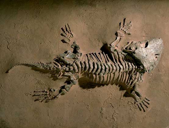
Permian period. Changes in natural conditions, which began in the Late Carboniferous, became even more pronounced in the Permian period, which ended the Paleozoic era. Its name comes from the Perm region in Russia. At the beginning of this period, the sea occupied the Ural geosyncline - a trough that followed the strike of the modern Ural Mountains. The shallow sea periodically covered some areas of England, northern France and southern Germany, where layered strata of marine and continental sediments accumulated - sandstones, limestones, shale and rock salt. The Tethys Sea existed for most of the period, and a thick limestone stratum was formed in the region of northern India and the modern Himalayas. Thick Permian deposits are found in eastern and central Australia and on the islands of South and Southeast Asia. They are widely distributed in Brazil, Bolivia and Argentina, as well as in southern Africa. Many Permian formations in northern India, Australia, Africa, and South America are of continental origin. They are represented by compacted glacial deposits, as well as widespread water-glacial sands. In Central and South Africa, these rocks begin a thick sequence of continental deposits, known as the Karoo series. In North America, the Permian seas occupied a smaller area compared to previous periods of the Paleozoic. The main transgression spread from the western part of the Gulf of Mexico to the north through the territory of Mexico and penetrated into the southern regions of the central part of the United States. The center of this epicontinental sea was located within the modern state of New Mexico, where a thick series of limestones of the Capiten series was formed. Thanks to the activity of groundwater, these limestones acquired a honeycomb structure, which is especially pronounced in the famous Carlsbad Caves (New Mexico, USA). To the east, in Kansas and Oklahoma, coastal red shale facies were deposited. At the end of the Permian, when the area occupied by the sea was significantly reduced, powerful saline and gypsum-bearing strata formed. At the end of the Paleozoic era, partly in the Carboniferous and partly in the Permian, orogeny began in many areas. Thick strata of sedimentary rocks of the Appalachian geosyncline were crumpled into folds and broken by faults. As a result, the Appalachian Mountains were formed. This stage of mountain building in Europe and Asia is called Hercynian, or Varisian, and in North America - Appalachian. The flora of the Permian period was the same as in the second half of the Carboniferous. However, the plants were smaller and not as numerous. This indicates that the climate of the Permian period became colder and drier. The invertebrates of the Permian were inherited from the previous period. A great leap has taken place in the evolution of vertebrates (Fig. 13). On all continents, Permian continental deposits contain numerous remains of reptiles, reaching a length of 3 m. All these ancestors of the Mesozoic dinosaurs were distinguished by a primitive structure and outwardly looked like lizards or alligators, but sometimes had unusual features, for example, a high sail-like fin stretching from the neck to the tail along the back, in Dimetrodon. Stegocephalians were still numerous.
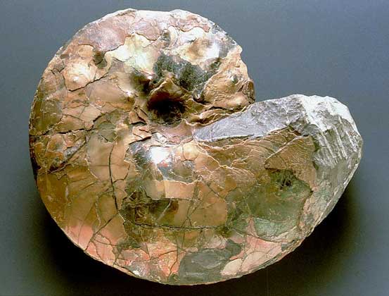
At the end of the Permian period, mountain building, which manifested itself in many regions of the globe against the background of a general uplift of the continents, led to such significant changes in the environment that many characteristic representatives of the Paleozoic fauna began to die out. The Permian period was the final stage in the existence of many invertebrates, especially trilobites. The Mesozoic era, subdivided into three periods, differed from the Paleozoic in the predominance of continental settings over marine ones, as well as in the composition of flora and fauna. Terrestrial plants, many groups of invertebrates, and especially vertebrates, have adapted to new environments and have undergone significant changes. The Triassic period opens the Mesozoic era. Its name comes from the Greek. trias (trinity) in connection with a clear three-membered structure of the stratum of deposits of this period in northern Germany. Red-colored sandstones occur at the base of the sequence, limestones in the middle, and red-colored sandstones and shales at the top. During the Triassic, large areas of Europe and Asia were occupied by lakes and shallow seas. The epicontinental sea covered Western Europe, and its coastline can be traced to the territory of England. The aforementioned stratotype sediments accumulated in this marine basin. The sandstones occurring in the lower and upper parts of the sequence are partly of continental origin. Another Triassic marine basin penetrated the territory of northern Russia and spread to the south along the Ural trough. The huge Tethys Sea then covered approximately the same territory as in the Late Carboniferous and Permian times. A thick layer of dolomitic limestones has accumulated in this sea, which form the Dolomites of northern Italy. In south-central Africa, most of the upper sequence of the Karoo continental series is of Triassic age. These horizons are known for the abundance of reptile fossils. At the end of the Triassic, covers of silts and sands of continental genesis formed on the territory of Colombia, Venezuela and Argentina. The reptiles found in these layers show a striking resemblance to the fauna of the Karoo series in southern Africa. In North America, Triassic rocks are not as widespread as in Europe and Asia. The destruction products of the Appalachians - red-colored continental sands and clays - accumulated in depressions located to the east of these mountains and experienced subsidence. These deposits, interbedded with lava horizons and sheet intrusions, are fractured and dip to the east. In the Newark Basin in New Jersey and the Connecticut River Valley, they correspond to bedrocks of the Newark series. Shallow seas occupied some of the western regions of North America, where limestone and shale accumulated. Continental sandstones and shales of the Triassic emerge along the sides of the Grand Canyon (in Arizona). The organic world in the Triassic period was essentially different than in the Permian period. This time is characterized by an abundance of large coniferous trees, the remains of which are often found in Triassic continental deposits. Shales of the Chinle Formation in northern Arizona are saturated with silicified tree trunks. As a result of the weathering of the shales, they were exposed and now form a stone forest. Cycads (or cycadophytes), plants with thin or barrel-shaped trunks and leaves hanging from the crown dissected, like those of palm trees, were widely developed. Some species of cycads also exist in modern tropical regions. Of the invertebrates, the most common were mollusks, among which ammonites predominated (Fig. 14), which had a distant resemblance to modern nautiluses (or boats) and a multi-chambered shell. There were many types of bivalves. Significant progress has taken place in the evolution of vertebrates. Although stegocephalians were still quite common, reptiles began to predominate, among which many unusual groups appeared (for example, phytosaurs, whose body shape was like that of modern crocodiles, and their jaws were narrow and long with sharp conical teeth). In the Triassic, real dinosaurs first appeared, evolutionarily more advanced than their primitive ancestors. Their limbs were directed downwards, and not to the sides (as in crocodiles), which allowed them to move like mammals and keep their bodies above the ground. Dinosaurs moved on their hind legs, maintaining balance with a long tail (like a kangaroo), and were small in height - from 30 cm to 2.5 m. Some reptiles adapted to life in the marine environment, for example, ichthyosaurs, whose body looked like a shark, and the limbs were transformed into something between flippers and fins, and plesiosaurs, whose body became flattened, the neck stretched, and the limbs turned into flippers. Both of these groups of animals became more numerous in later stages of the Mesozoic era.
The Jura period takes its name from the Jura mountains (in northwestern Switzerland), composed of a multi-layered stratum of limestone, shale and sandstone. The Jurassic saw one of the largest marine transgressions in Western Europe. The huge epicontinental sea spread over most of England, France, Germany and penetrated into some western regions of European Russia. Numerous outcrops of Upper Jurassic lagoonal fine-grained limestones are known in Germany, in which unusual fossils have been found. In Bavaria, in the famous town of Solenhofen, the remains of winged reptiles and both of the known species of the first birds were found. The Tethys Sea stretched from the Atlantic through the southern part of the Iberian Peninsula along the Mediterranean Sea and through South and Southeast Asia to the Pacific Ocean. Most of northern Asia during this period was located above sea level, although the epicontinental seas penetrated into Siberia from the north. Jurassic continental deposits are known in southern Siberia and northern China. Small epicontinental seas occupied limited areas along the coast of western Australia. In the interior of Australia, there are outcrops of Jurassic continental deposits. Much of Africa during the Jurassic was above sea level. The exception was its northern margin, which was flooded by the Tethys Sea. In South America, an elongated narrow sea filled a geosyncline located approximately at the site of the modern Andes. In North America, the Jurassic seas occupied very limited territories in the west of the mainland. Thick strata of continental sandstones and overlying shales have accumulated in the area of the Colorado Plateau, especially to the north and east of the Grand Canyon. Sandstones were formed from the sands that made up the desert dune landscapes of the basins. As a result of weathering processes, sandstones have acquired unusual shapes (for example, the picturesque pointed peaks in Zion National Park or the Rainbow Bridge National Monument, which is an arch towering 94 m above the canyon floor with a span of 85 m; these attractions are located in Utah). The shale deposits of the Morrison Formation are famous for the finds of 69 species of fossil dinosaurs. Finely dispersed sediments in this region probably accumulated in the conditions of a swampy lowland. The flora of the Jurassic period was in general similar to that which existed in the Triassic. The flora was dominated by cycads and conifers. For the first time, Ginkgoaceae appeared - gymnosperms of broad-leaved woody plants with foliage falling in autumn (probably this is a link between gymnosperms and angiosperms). The only species of this family - ginkgo biloba - has survived to this day and is considered the most ancient representative of trees, a truly living fossil. The Jurassic fauna of invertebrates is very similar to the Triassic. However, reef-building corals became more numerous, and sea urchins and mollusks became widespread. Many bivalve mollusks related to modern oysters appeared. There were still numerous ammonites. Vertebrates were predominantly reptiles, since the stegocephalians became extinct at the end of the Triassic. Dinosaurs have reached the climax of their development. Such herbivorous forms as apatosaurs and diplodocus began to move on four limbs; many had long necks and tails. These animals acquired gigantic dimensions (up to 27 m in length), and some weighed up to 40 tons. Individual representatives of smaller herbivorous dinosaurs, such as stegosaurus, developed a protective shell consisting of plates and spikes. Carnivorous dinosaurs, in particular allosaurs, developed large heads with powerful jaws and sharp teeth, they reached 11 m in length and moved on two limbs. Other groups of reptiles were also very numerous. Plesiosaurs and ichthyosaurs lived in the Jurassic seas. For the first time, flying reptiles appeared - pterosaurs, in which membranous wings developed, like those of bats, and their mass decreased due to tubular bones. The appearance of birds in the Jurassic is an important stage in the development of the animal world. Two bird skeletons and feather impressions have been found in the lagoonal limestones of Solenhofen. However, these primitive birds still had many features in common with reptiles, including sharp conical teeth and long tails. The Jurassic period ended with intense folding that formed the Sierra Nevada mountains in the western United States, which extended further north into present-day western Canada. Subsequently, the southern part of this folded belt again experienced uplift, which predetermined the structure of modern mountains. On other continents, manifestations of orogeny in the Jurassic were insignificant.
Cretaceous period. At this time, powerful layered strata of soft, weakly compacted white limestone accumulated - chalk, from which the name of the period originated. For the first time, such layers were studied in outcrops along the banks of the Pas de Calais near Dover (Great Britain) and Calais (France). In other parts of the world, deposits of the corresponding age are also called Cretaceous, although other types of rocks are also found there. During the Cretaceous, marine transgressions covered large parts of Europe and Asia. In central Europe, the seas flooded two sublatitudinal geosynclinal troughs. One of them was located within southeastern England, northern Germany, Poland, and western regions of Russia, and reached the submeridional Ural trough in the extreme east. Another geosyncline, Tethys, retained its former strike in southern Europe and northern Africa and connected with the southern tip of the Ural trough. Further, the Tethys Sea continued in South Asia and, east of the Indian Shield, connected with the Indian Ocean. With the exception of the northern and eastern margins, the territory of Asia during the entire Cretaceous period was not flooded by the sea, therefore continental deposits of this time are widespread there. Thick layers of Cretaceous limestones are present in many parts of Western Europe. In the northern regions of Africa, where the Tethys Sea entered, large strata of sandstones accumulated. The sands of the Sahara desert were formed mainly due to the products of their destruction. Australia was covered with chalk epicontinental seas. In South America, during most of the Cretaceous period, the Andean trough was flooded by the sea. To the east of it, in a large area of Brazil, terrigenous silts and sands with numerous remains of dinosaurs were deposited. In North America, the marginal seas occupied the coastal plains of the Atlantic Ocean and the Gulf of Mexico, where sands, clays, and chalk limestones accumulated. Another marginal sea was located on the western coast of the mainland within California and reached the southern foothills of the revived Sierra Nevada mountains. However, the last largest marine transgression covered the western regions of the central part of North America. At this time, a vast geosynclinal trough of the Rocky Mountains formed, and a huge sea spread from the Gulf of Mexico through the modern Great Plains and Rocky Mountains north (west of the Canadian Shield) up to the Arctic Ocean. During this transgression, a thick layered sequence of sandstones, limestones, and shales was deposited. At the end of the Cretaceous, intensive orogeny took place in South and North America and East Asia. In South America, sedimentary rocks accumulated in the Andean geosyncline over several periods were compacted and crumpled into folds, resulting in the formation of the Andes. Similarly, in North America, the Rocky Mountains formed at the site of the geosyncline. Volcanic activity has intensified in many parts of the world. Lava flows covered the entire southern part of the Hindustan Peninsula (thus the vast Deccan Plateau was formed), and small outpourings of lava took place in Arabia and East Africa. All continents experienced significant uplifts, and all geosynclinal, epicontinental, and marginal seas regressed. The Cretaceous period was marked by several major events in the development of the organic world. The first flowering plants appeared. Their fossil remains are represented by leaves and wood species, many of which are still growing today (for example, willow, oak, maple and elm). The Cretaceous fauna of invertebrates is generally similar to that of the Jurassic. Among vertebrates, the culmination of the species diversity of reptiles has come. There were three main groups of dinosaurs. Carnivores with well-developed massive hind limbs were represented by tyrannosaurs, which reached 14 m in length and 5 m in height. A group of bipedal herbivorous dinosaurs (or trachodonts) with wide flattened jaws resembling a duck beak developed. Numerous skeletons of these animals are found in the Cretaceous continental deposits of North America. The third group includes horned dinosaurs with a developed bone shield that protected the head and neck. A typical representative of this group is a Triceratops with a short nasal and two long supraocular horns. Plesiosaurs and ichthyosaurs lived in the Cretaceous seas, and mosasaur sea lizards with an elongated body and relatively small flipper-like limbs appeared. Pterosaurs (flying lizards) lost their teeth and moved better in the air than their Jurassic ancestors. In one of the species of pterosaurs - pteranodon - the wingspan reached 8 m. Two species of birds of the Cretaceous period are known that have retained some morphological features of reptiles, for example, conical teeth placed in the alveoli. One of them - hesperornis (diving bird) - has adapted to life in the sea. Although transitional forms more similar to reptiles than mammals have been known since the Triassic and Jurassic, for the first time numerous remains of true mammals were found in continental Upper Cretaceous deposits. The primitive mammals of the Cretaceous period were small in size and somewhat resembled modern shrews. The processes of mountain building and the tectonic uplift of the continents at the end of the Cretaceous period, which were widely developed on Earth, led to such significant changes in nature and climate that many plants and animals died out. From the invertebrates, the ammonites that dominated the Mesozoic seas disappeared, and from the vertebrates, all dinosaurs, ichthyosaurs, plesiosaurs, mosasaurs and pterosaurs disappeared. The Cenozoic era, covering the last 65 million years, is divided into the Tertiary (in Russia it is customary to distinguish two periods - the Paleogene and the Neogene) and the Quaternary periods. Although the latter was notable for its short duration (age estimates of its lower boundary range from 1 to 2.8 million years), it played a great role in the history of the Earth, since repeated continental glaciations and the appearance of man are associated with it.
Tertiary period. At that time, many areas of Europe, Asia, and North Africa were covered with shallow epicontinental and deep-water geosynclinal seas. At the beginning of this period (in the Neogene), the sea occupied southeastern England, northwestern France and Belgium, and a thick layer of sands and clays accumulated there. The Tethys Sea still continued to exist, stretching from the Atlantic to the Indian Ocean. Its waters flooded the Iberian and Apennine peninsulas, the northern regions of Africa, southwestern Asia and the north of Hindustan. Thick limestone horizons were deposited in this basin. Most of northern Egypt is composed of nummulite limestone, which was used as a building material in the construction of the pyramids. At this time, almost all of southeast Asia was occupied by marine basins and a small epicontinental sea extended into southeast Australia. Tertiary marine basins covered the northern and southern extremities of South America, and the epicontinental sea penetrated into the territory of eastern Colombia, northern Venezuela and southern Patagonia. Thick strata of continental sands and silts accumulated in the Amazon basin. The marginal seas were located on the site of the modern Coastal Plains adjacent to the Atlantic Ocean and the Gulf of Mexico, as well as along the western coast of North America. Thick strata of continental sedimentary rocks, formed as a result of the denudation of the revived Rocky Mountains, accumulated on the Great Plains and in intermountain depressions. Active orogeny took place in many regions of the globe in the middle of the Tertiary period. In Europe, the Alps, Carpathians and the Caucasus were formed. In North America, the final stages of the Tertiary formed the Coast Ranges (within the present-day states of California and Oregon) and the Cascade Mountains (within Oregon and Washington). The Tertiary period was marked by significant progress in the development of the organic world. Modern plants originated in the Cretaceous period. Most Tertiary invertebrates were directly inherited from Cretaceous forms. Modern bony fishes have become more numerous, the abundance and species diversity of amphibians and reptiles have decreased. There was a leap in the development of mammals. From primitive shrew-like forms that first appeared in the Cretaceous period, many forms date back to the beginning of the Tertiary period. The oldest fossil remains of horses and elephants have been found in Lower Tertiary rocks. Carnivorous and artiodactyl animals appeared. The species diversity of animals increased greatly, but many of them died out by the end of the Tertiary period, while others (like some Mesozoic reptiles) returned to the marine lifestyle, such as cetaceans and porpoises, in which the fins are transformed limbs. Bats were able to fly thanks to the membrane that connects their long fingers. Dinosaurs, which became extinct at the end of the Mesozoic, gave way to mammals, which became the dominant animal class on land at the beginning of the Tertiary period. The Quaternary is subdivided into the Eopleistocene, Pleistocene and Holocene. The latter began only 10,000 years ago. The modern relief and landscapes of the Earth basically took shape in the Quaternary period. Mountain building, which took place at the end of the Tertiary period, predetermined the significant uplift of the continents and the regression of the seas. The Quaternary period was marked by a significant cooling of the climate and the widespread development of ice sheets in Antarctica, Greenland, Europe and North America. In Europe, the center of glaciation was the Baltic Shield, from where the ice sheet extended to southern England, central Germany and the central regions of Eastern Europe. In Siberia, ice cover was smaller, mainly limited to foothill areas. In North America, ice sheets covered a vast area, including most of Canada and the northern regions of the United States as far as southern Illinois. In the Southern Hemisphere, the Quaternary ice sheet is characteristic not only of Antarctica, but also of Patagonia. In addition, mountain glaciation was widespread on all continents. In the Pleistocene, four main stages of glaciation activation are distinguished, alternating with interglacials, during which natural conditions were close to modern or even warmer. The last ice sheet in Europe and North America reached its largest size 18-20 thousand years ago and finally melted at the beginning of the Holocene. In the Quaternary period, many tertiary forms of animals died out and new ones appeared, adapted to colder conditions. Of particular note are the mammoth and the woolly rhinoceros, which inhabited the northern regions in the Pleistocene. In the more southern regions of the Northern Hemisphere, mastodons, saber-toothed tigers, etc. were found. When the ice sheets melted, representatives of the Pleistocene fauna died out and modern animals took their place. Primitive people, in particular Neanderthals, probably already existed during the last interglacial period, but a modern type of man - a reasonable man (Homo sapiens) - appeared only in the last ice age of the Pleistocene, and in the Holocene settled throughout the globe.
Big Encyclopedic Dictionary