Following the example of previous round-the-world voyages in the expedition of 1826-1829. for scientific research on the coast of the Bering Sea, the Asian and American continents, as well as research in the central part of the Pacific Ocean (between 30 ° N and the equator), two warships were equipped: the sloop "Moller" under the command of M. N. Stanyukovich and sloop "Senyavin" under the command of F. P. Litke. It was believed that Litke sailed under the command of Stanyukovich, but in essence he carried out all the research independently and independently of the latter. This expedition can be considered joint only by sailing to the places of research and returning to St. Petersburg, but even then the ships often parted and each acted at his own discretion, only adhering to the instructions on the meeting points.
Each of the commanders of the ships were given separately detailed instructions about their independent research. If Stanyukovich was instructed to describe the eastern coast of the Bering Sea, that is, the coast of northwestern America (from the Bering Strait to the extreme southern Russian settlements), and to explore the eastern sector of the central Pacific Ocean, including the Hawaiian and other islands, then Litke had to conduct research in the western sector of the central part of the Pacific Ocean and on the coast of Asia (from the Bering Strait to Sakhalin).
In terms of its scientific significance, Litke's voyage in many respects surpasses the results of research on the Moller ship under the command of Stanyukovich. Let us first dwell on the studies carried out by the Senyavin sloop under the command of Lntke.
F. P. Litke
The crew of the sloop "Senyavin" was small (62 people), but combative and well-coordinated. Along with Litke and senior officers Zavalishin and Aboleshev, natural scientists took part in the voyage: K. G. Mertens (zoologist and botanist), A. F. Pastels (mineralogist and artist) and Kitlits (ornithologist).
F. P. Litke, before going on a circumnavigation, already had an outstanding experience in driving ships and scientific research. The results of his four voyages in the Arctic Ocean and the study of Novaya Zemlya were well known outside of Russia.
The considerations of the Naval Ministry were quite understandable when Litke was appointed commander of the ship "Senyavin", which set off on a round-the-world voyage. This appointment pleased Litke, since swimming opened up broad prospects for independent scientific research in various fields of natural science.
In the instruction of the State Admiralty Department, given to Litke, a very extensive plan was outlined, the implementation of which would have required several more expeditions. Off the coast of Asia, he had to describe, starting research from the Bering Strait, “the lands of the Chukchi and Koryaks and the Kamchatka Peninsula”, “the shores of the Sea of \u200b\u200bOkhotsk and the Shantar Islands, which, although known to us, are not sufficiently described”, describe the islands of St. Matthew in Bering Sea. In particular detail, as indicated in the instructions, the Anadyr and Olyutorsky bays should be described and the lands adjacent to them should be studied, for which it was recommended to send natural scientists from the ship into the country.
In the Sea of Okhotsk - "start an inventory of the coast lying between Sakhalin and the Udsk prison, including the Shantar Islands in it", and then go to its northern shores and describe the coast lying east of Okhotsk, and the coast of Kamchatka.
During the winter months, Litke was supposed to explore the central regions and islands of the Pacific Ocean, including the islands of Bonin Sima, Caroline, Mariana, Marshall, and others. the accomplishment is left to you, bringing only to you in appearance: 1) in order to inspect the place on the way, in which on some maps the islands under the name of Bonin-Sima have recently begun to be indicated; 2) that you must explore the entire space in which the archipelago of the Caroline Islands is located, starting from the Marshall Islands to the Pelevskie Islands, and extend your research to the very equator; the Mariana Islands and the Yualan Island present you with convenient places of refreshment. You do not need to go west of the Marshall Islands, because the space lying to the east of these islands is assigned to Lieutenant Commander Stanyukovich.
If for some reason you return alone to Russia, it is advisable that you examine the northern side of the Soloman Islands, then the northern side of New Ireland and New Hanover and the islands lying at a short distance from them.
On August 20, 1826, the ships put to sea. In England, it was necessary to purchase astronomical and physical instruments, as well as some marine equipment. While these purchases were being made, Litke was conducting research at the Greenwich Observatory on the phenomena of terrestrial magnetism, and got acquainted with British scientists.
They did not stay long at intermediate stops on the coast of Brazil and Chile.
In the Pacific Ocean, its equatorial part, on the way to northwestern America, Litke carried out geomagnetic observations. He established the direction of the magnetic equator.
No less interesting for travelers was visiting Novoarkhangelsk in Sitka Bay and Unalashka Island, where excursions and observations were also conducted. The ruler of Novoarkhangelsk handed over to Litka Baranov's manuscripts about local residents that were kept here.
Passing along the Aleutian ridge, Litke decided to go to the island of St. Matthew, to clarify its geographical coordinates. The coast of the island of St. Matthew was accurately marked by Litke on a geographical map, the collection of Mertens and Kitlitz was replenished. September 13, 1827 were in Petropavlovsk in Kamchatka. From here it was necessary to begin the research provided for by the expedition plan (Fig. 10).
In the winter of 1827/28, Litke decided to explore the Caroline Archipelago. He began his research of the archipelago from the eastern island of Yualan, where a number of scientific observations (geomagnetic, astronomical, etc.) were made, many species of local birds (wild chickens, head-over-headed deer, shorebirds, etc.), rare specimens of marine animals (spintails, needlegills, cuckolds, red beards, etc.). Many insects were dried and alcoholized.
Moving from the island of Yualan to the west, the expedition described, specifying geographical coordinates, the known islands and mapped the newly discovered ones. So, a chain of coral islands was discovered, called Litke, with the consent of the crew, the Senyavin Islands. Litke tried to make a hydrographic description of some of them, but due to the unfriendly attitude of the natives, he was forced to abandon his intention. Besides, there was little time left. They stayed for a few days only at the island of Lugunor. From local residents we learned about the names of the islands in the group discovered by Litka. Native names appeared on the map: Piinipet, Air, Kuruburui, Avada, etc.
From the Senyavin Islands we went to the famous but unexplored Los Valientas Islands, which are part of the Caroline Archipelago, and then to the Martlock Islands. On the latter they landed, carried out a hydrographic description of the harbor on the island of Lugunor. Naturalists, using the parking lot, replenished the collections. In the further voyage, they met a number of islands belonging to the Namoluk, Anonymous (Pisararr) group, and others. The expedition replenished food and water supplies on the island of Guaham. In Santa Cruz, Russian sailors were greeted as if they had known each other for a long time. Here Litke met the Spanish explorer of the Caroline Islands Luis Torres, who warmly received Litke and put at his disposal his journal describing the life, customs and religion of local tribes.
Litke carefully examined individual groups of islands and did not miss a single one, even of little significance. Fellow sailors said about him that Litke walks on the ocean, as if in his own house. Having completed the survey of the Caroline Islands, the expedition turned north - to the islands of Bonin Sima. But since they were described in 1827 by Captain Beachy, they did not stay here. Summer and autumn 1828 "Senyavin" was in the northern waters of the Pacific Ocean. Leaving Petropavlovsk, Litke determined the exact geographical coordinates of peninsulas and capes, bays and bays. He decided to complete a detailed hydrographic description upon his return. Several days were spent describing Karaginsky Island and finding a harbor on it. Having successfully completed the research, the expedition headed north, where they clarified the position of Verkhotursky Island, which was located at a distance of fifty miles from Karaginsky Island, and not five, as the maps indicated. Having described several capes of the Asian coast and passing the island of St. Lawrence, they entered the Bering Strait. From here, in the foggy distance, one could see the mountains on the mainland of Asia and America. Describing the coast of the island of Arakamchechen and the Asian coast, Litke mapped new bays and straits, noted some mountain peaks. This is how the Russian names of the Senyavin Strait, Ratmanov harbor (on the island of Arakamchechen), Mount Postels (on the island of Ittygran) appeared.
Having completed the inventory of the Gulf of the Holy Cross, Litke decided to explore the mouth of the river. Anadyr, however, a sharp change in the weather forced the travelers to turn south. Behind Cape St. Fadey, an unnamed cape was marked on the map, to which Litke gave the name Navarin, and the mountain on it - the name of Heiden. A few days later, the Senyavin sloop met the Moller sloop in Petropavlovsk.
On the way back to Europe, Litke visited the northern group of the Caroline Islands - the islands of Murille, Farroylap, and others. The small coral islands encountered by Litke were also examined and mapped. The sailors were surprised by the calmness with which Litke led the ship along the intended course and entered everything he saw in the log. The islands of Mogmog, Zapap, Ngoli, Lamoniur, Ear, Falalep and many others were explored. After resting and equipping ships in Manila, the travelers set off through the Sunda Strait and past the coast of Java to the Indian Ocean - and to Europe.
August 25, 1829 "Senyavin" returned to Kronstadt. A lot of time and work was occupied by the processing of materials and observations of the expedition. Its results were set forth in several volumes of essays later published by Litke.
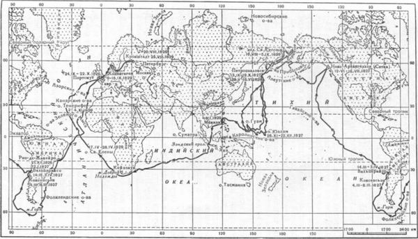
Rice. 10. The route of circumnavigation of F. P. Litke on the sloop "Senyavin" (1826-1829)
Litke summarized the results of the expedition in the first part of his work. First of all, he noted geographical and hydrographic studies (Fig. 11, 12). The most important points of the coast of Kamchatka north of Avacha Bay have been astronomically determined, the heights of many hills have been measured, the islands of Karaginsky, St. Matthew, Pribylova, some of the Aleutian Islands, as well as the coast of the Chukotka Peninsula from Cape Dezhnev to the mouth of the Anadyr. In another region, in the archipelago of the Caroline Islands, a vast area from Yualan Island to the Uleai group was surveyed. 12 have been discovered, and 26 groups or individual islands have been described. Maps and plans (more than 50) were compiled for all the studied places, which were included in the nautical atlas published by the Hydrographic Depot of the Naval Staff.
Of great interest were observations in zoology and botany. Several new species of animals were collected (bats, seals, cranial reptiles, etc.); a large number of specimens of fish, three hundred species of birds, about seven hundred species of insects were collected, many of which were little or completely unknown to science. The herbarium included up to 2500 phanerogamous plants (including ferns). Attention was drawn to the distribution of vegetation across countries, which determines the types of plants in a particular country. Rocks collected from all places amounted to 330 samples.
The natural scientists A.F. Pastels, K.G. Mertens, and Kitlitz played an important role in scientific research and the collection of collections in zoology and botany during the Litke expedition. Glory to Litke as a scientist grew as he published reports on the expedition. Publication of the last volume "Traveling around the world on the military sloop "Senyavin" in 1826-1828" called an event in geography. His work received the highest award of the St. Petersburg Academy of Sciences - the full Demidov Prize. Many scientists used the data of Litke's research, his works were translated into European languages and were highly appreciated by foreign scientists (A. Humboldt, J. Cuvier, etc.).
The results of Litke's observations over a permanent pendulum over a vast expanse of the Earth (from 70°N to 38°S) led to the conclusion that the Earth is not a regular ellipsoid of revolution, as previously thought. A great contribution to oceanographic science is his views on the ebb and flow, as well as currents.
Litke's contribution to ethnography is very significant. He described the life and customs of many tribes that inhabited the islands of the Pacific Ocean, the coasts of northeast Asia and northwest America. Less significant scientific results ended the voyage of the second ship of this expedition - the sloop "Moller" under the command of Stanyukovich.
Rice. 11. Travel tables of observations on the state of the ocean waters and the atmosphere from Litke's essay "Journey ..."
From Valparaiso (Chile), the Moller headed for the Tuamotu Islands. Having examined and determined the geographical coordinates of some places (the islands of Lito, Lazarev, etc.), the ship passed them, and then passed by the Hawaiian Islands and in July 1827 arrived in Petropavlovsk.
Research on the coast of Russian America in 1827 failed, as the autumn time had come. Winds and fogs interrupted at the beginning the hydrographic inventory near Unimak Island. After a month-long stay in Novo-Arkhangelsk, Stanyukovich sailed to the Hawaiian Islands, where he decided to explore the waters to the east and north-west of the islands and find there the islands that were listed on the map and allegedly discovered earlier.
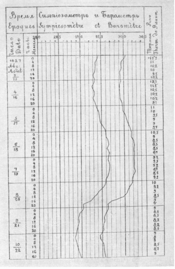
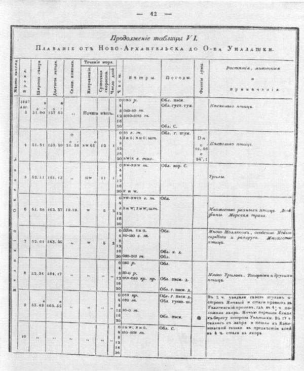
Fig. 12. Graph showing daily 6-fold observations of humidity, pressure and air temperature in the navigation section from Novo-Arkhangelsk to about. Unalaska (Litke, 1835, separate navigator, p. 43)
Stanyukovich began the inventory of the American coast of the northern part of the Pacific Ocean only at the beginning of June 1828. Before that, in Unalaska, he had checked physical instruments, for the inventory of the coast in shallow water, canoes with Aleuts were taken on board. The expedition managed to only partially describe the northern coast of the Alaska Peninsula and Bristol Bay to the mouth of the river. Naknek. When describing the shores, Stanyukovich, like other navigators, used the method of describing the shores of Admiral Sarychev tested by Russian sailors. The vessel stopped at anchor, and the inventory was carried out from rowboats and canoes. Along the way, the Moller team examined the Aleutian Islands, some of them were described, for example, the islands of Amak (Khudiakova), Unimak, and others.
The report on Stanyukovich's research on the Moller was not published, and they remained less known than Litke's research on the Senyavin.
Highly appreciating the results of the expedition of Stanyukovich and Litke, it should be noted that the crews of the ships, and especially on the Moller, did not use all the possibilities to carry out their tasks. A lot of time was occupied by stops in ports, delays when sailing in the tropics, where research for the expedition was considered secondary.
This expedition, as N. N. Zubov correctly noted, certainly could have done much more according to the inventory of domestic seas.
Forward
Table of contents
Back